
Ferraz de Vasconcelos topographic map
Interactive map
Click on the map to display elevation.
Ferraz de Vasconcelos
Ferraz de Vasconcelos is situated in the eastern region of Greater São Paulo. Altitude: 759 meters above sea level. Limits are Poa and Suzano east, São Paulo west, Mauá southwest Ribeirão Pires and south Itaquaquecetuba north .
About this map
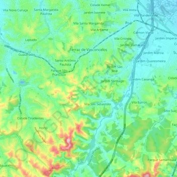
Name: Ferraz de Vasconcelos topographic map, elevation, terrain.
Average elevation: 791 m
Minimum elevation: 730 m
Maximum elevation: 952 m
Other topographic maps
Click on a map to view its topography, its elevation and its terrain.
São Paulo
Brazil > São Paulo > Região Metropolitana de São Paulo > São Paulo
São Paulo is in Southeastern Brazil, in southeastern São Paulo State, approximately halfway between Curitiba and Rio de Janeiro. The city is on a plateau placed beyond the Serra do Mar (Portuguese for "Sea Range" or "Coastal Range"), itself a component of the vast region known as the Brazilian Highlands,…
Average elevation: 785 m
Sitio Borda da Mata
Brazil > São Paulo > Região Metropolitana de São Paulo > Franco da Rocha
Average elevation: 793 m
Praça Bartolomeu de Messina
Brazil > São Paulo > Região Metropolitana de São Paulo > São Paulo
Average elevation: 790 m
São Bernardo do Campo
Brazil > São Paulo > Região Metropolitana de São Paulo > São Bernardo do Campo
Average elevation: 760 m
Santo André
Brazil > São Paulo > Região Metropolitana de São Paulo > Santo André
Average elevation: 776 m