
Parroquia San Antonio de los Altos topographic map
Interactive map
Click on the map to display elevation.
Parroquia San Antonio de los Altos
San Antonio de los Altos is part of the Altos Mirandinos Metropolitan Area, which is, in itself part of the Metropolitan Region of Caracas. It covers an area of about 55 km2 (21 sq mi) and has an average altitude of 1,300 metres (4,300 ft) above sea level. San Antonio is the highest point in the Altos Mirandinos area.
About this map
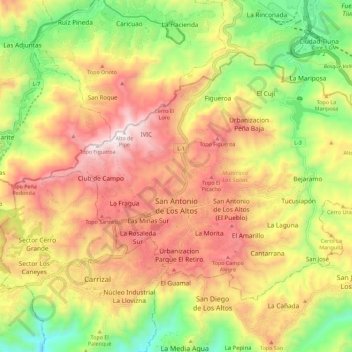
Name: Parroquia San Antonio de los Altos topographic map, elevation, terrain.
Average elevation: 1,240 m
Minimum elevation: 736 m
Maximum elevation: 1,727 m