Geolocate

Village of Mamaroneck topographic map

Interactive map

Click on the map to display elevation.

About this map

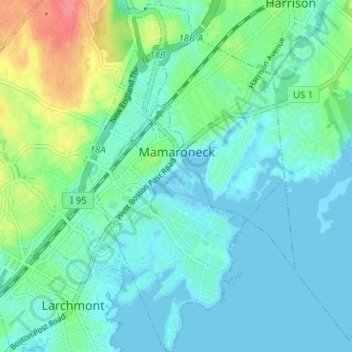
Name: Village of Mamaroneck topographic map, elevation, terrain.

Location: Village of Mamaroneck, Town of Mamaroneck, Westchester County, New York, 10543, United States (40.92154 -73.74992 40.96938 -73.71373)

Average elevation: 15 m

Minimum elevation: -3 m

Maximum elevation: 65 m

Other areas of the town include Heathcote Hill, overlooking the harbor, Harbor Heights (the heights) to the northeast, Old Rye Neck (settled in the 1880s), Rye Neck (settled in the 1920s and 1930s), Orienta, and Washingtonville, better known as "The Flats", due to the flat, low-lying topography of the area.

Other topographic maps

Click on a map to view its topography, its elevation and its terrain.

City of New Rochelle

United States > New York > Westchester County

City of New Rochelle, Westchester County, New York, United States

Average elevation: 31 m

Salem Center

United States > New York > Westchester County > Town of North Salem

Salem Center, Town of North Salem, Westchester County, New York, 10560, United States

Average elevation: 147 m

Town of North Salem

United States > New York > Westchester County

Town of North Salem, Westchester County, New York, United States

Average elevation: 179 m

Isle of San Souci

United States > New York > Westchester County > City of New Rochelle

Isle of San Souci, City of New Rochelle, Westchester County, New York, 10805, United States

Average elevation: 7 m

Getty Square

United States > New York > Westchester County > City of Yonkers > Ludlow

Getty Square, Ludlow, City of Yonkers, Westchester County, New York, United States

Average elevation: 31 m

Van Cortlandtville

United States > New York > Westchester County > Town of Cortlandt

Van Cortlandtville, Town of Cortlandt, Westchester County, New York, 10567, United States

Average elevation: 80 m

Wykagyl Park

United States > New York > Westchester County > City of New Rochelle

Wykagyl Park, City of New Rochelle, Westchester County, New York, 10804, United States

Average elevation: 41 m

City of Yonkers

United States > New York > Westchester County

City of Yonkers, Westchester County, New York, United States

Average elevation: 58 m

Murray Hill

United States > New York > Westchester County > Village of Scarsdale

Murray Hill, Village of Scarsdale, Westchester County, New York, 10583, United States

Average elevation: 79 m

Sun Haven

United States > New York > Westchester County > City of New Rochelle

Sun Haven, City of New Rochelle, Westchester County, New York, 10538, United States

Average elevation: 20 m

Village of Port Chester

United States > New York > Westchester County

Village of Port Chester, Town of Rye, Westchester County, New York, 10573, United States

Average elevation: 25 m

Saw Mill River

United States > New York > Westchester County > Village of Irvington

Saw Mill River, Village of Irvington, Town of Greenburgh, Westchester County, New York, United States

Average elevation: 69 m

Village of Pleasantville

United States > New York > Westchester County

Village of Pleasantville, Town of Mount Pleasant, Westchester County, New York, 10570, United States

Average elevation: 124 m

Town of Lewisboro

United States > New York > Westchester County

Town of Lewisboro, Westchester County, New York, United States

Average elevation: 162 m

Lake Mohegan

United States > New York > Westchester County

Lake Mohegan, Town of Yorktown, Westchester County, New York, 10547, United States

Average elevation: 140 m

West Mount Vernon

United States > New York > Westchester County > City of Mount Vernon

West Mount Vernon, City of Mount Vernon, Westchester County, New York, 10550, United States

Average elevation: 49 m

Town of Bedford

United States > New York > Westchester County

Town of Bedford, Westchester County, New York, United States

Average elevation: 142 m

Village of Sleepy Hollow

United States > New York > Westchester County

Village of Sleepy Hollow, Town of Mount Pleasant, Westchester County, New York, United States

Average elevation: 46 m

Village of Tuckahoe

United States > New York > Westchester County

Village of Tuckahoe, Town of Eastchester, Westchester County, New York, United States

Average elevation: 57 m

Town of Pound Ridge

United States > New York > Westchester County

Town of Pound Ridge, Westchester County, New York, 10576, United States

Average elevation: 156 m

City of White Plains

United States > New York > Westchester County

City of White Plains, Westchester County, New York, United States

Average elevation: 83 m

Katonah

United States > New York > Westchester County > Town of Bedford

Katonah, Town of Bedford, Westchester County, New York, United States

Average elevation: 94 m

Park Hill

United States > New York > Westchester County > City of Yonkers > Park Hill

Park Hill, City of Yonkers, Westchester County, New York, 10705, United States

Average elevation: 43 m

Chappaqua

United States > New York > Westchester County > Town of New Castle

Chappaqua, Town of New Castle, Westchester County, New York, United States

Average elevation: 145 m

Vista

United States > New York > Westchester County > Town of Lewisboro > Vista

Vista, Town of Lewisboro, Westchester County, New York, United States

Average elevation: 154 m

Village of Larchmont

United States > New York > Westchester County > Village of Larchmont

Village of Larchmont, Town of Mamaroneck, Westchester County, New York, 10538, United States

Average elevation: 8 m

City of Rye

United States > New York > Westchester County > City of Rye

City of Rye, Westchester County, New York, United States

Average elevation: 9 m

Yorktown Heights

United States > New York > Westchester County > Town of Yorktown > Yorktown Heights

Yorktown Heights, Town of Yorktown, Westchester County, New York, United States

Average elevation: 159 m

Valhalla

United States > New York > Westchester County > Town of Mount Pleasant > Valhalla

Valhalla, Town of Mount Pleasant, Westchester County, New York, 10595, United States

Average elevation: 110 m

Village of Scarsdale

United States > New York > Westchester County

Village of Scarsdale, Westchester County, New York, 10583, United States

Average elevation: 76 m

Bedford Hills

United States > New York > Westchester County > Town of Bedford > Bedford Hills

Bedford Hills, Town of Bedford, Westchester County, New York, 10507, United States

Average elevation: 114 m

Town of Mount Pleasant

United States > New York > Westchester County

Town of Mount Pleasant, Westchester County, New York, United States

Average elevation: 116 m

Town of Mamaroneck

United States > New York > Westchester County > Town of Mamaroneck

Town of Mamaroneck, Westchester County, New York, 10538, United States

Average elevation: 18 m

Katonah

United States > New York > Westchester County > Town of Bedford > Katonah

Katonah, Town of Bedford, Westchester County, New York, 10536, United States

Average elevation: 100 m

City of Peekskill

United States > New York > Westchester County

City of Peekskill, Westchester County, New York, 10566, United States

Average elevation: 67 m

Village of Ardsley

United States > New York > Westchester County

Village of Ardsley, Town of Greenburgh, Westchester County, New York, 10502, United States

Average elevation: 86 m

Village of Dobbs Ferry

United States > New York > Westchester County

Village of Dobbs Ferry, Town of Greenburgh, Westchester County, New York, United States

Average elevation: 54 m

Lewisboro

United States > New York > Westchester County > Lewisboro

Lewisboro, Town of Lewisboro, Westchester County, New York, 10590, United States

Average elevation: 183 m

Town of Cortlandt

United States > New York > Westchester County

Town of Cortlandt, Westchester County, New York, United States

Average elevation: 94 m