
Make a donation
Gear up for your next adventure:
As an Amazon Associate, this site earns from qualifying purchases at no extra cost to you.
Venice East topographic map
Click on the map to display elevation.
Make a donation
Gear up for your next adventure:
As an Amazon Associate, this site earns from qualifying purchases at no extra cost to you.
About this map
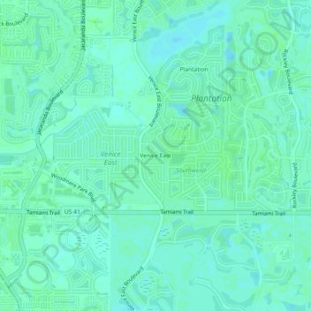
Name: Venice East topographic map, elevation, terrain.
Location: Venice East, Sarasota County, Florida, 34293, United States (27.03700 -82.39843 27.07700 -82.35843)
Average elevation: 6 m
Minimum elevation: 2 m
Maximum elevation: 10 m
Make a donation
Gear up for your next adventure:
As an Amazon Associate, this site earns from qualifying purchases at no extra cost to you.
Other topographic maps
Click on a map to view its topography, its elevation and its terrain.
North Port
United States > Florida > Sarasota County
North Port features a predominantly flat and low-lying topography characteristic of the region. The area is situated at an elevation of approximately 20 feet above sea level, with much of the terrain comprising wetlands, pine forests, and small lakes, interspersed with residential developments. The Myakka…
Average elevation: 6 m
Nokomis
United States > Florida > Sarasota County
Nokomis features a predominantly flat and low-lying terrain characteristic of the coastal region. The elevation in Nokomis rarely exceeds 15 feet above sea level, contributing to its vulnerability to tidal influences and storm surges. The area is interspersed with wetlands and mangroves, particularly near the…
Average elevation: 5 m
Make a donation
Gear up for your next adventure:
As an Amazon Associate, this site earns from qualifying purchases at no extra cost to you.
Venice
United States > Florida > Sarasota County
Venice is characterized by its predominantly flat terrain, situated at an elevation of approximately 15 feet above sea level. This coastal city features sandy beaches along the Gulf of Mexico and is interspersed with various waterways, including canals and lakes that contribute to its scenic environment. The…
Average elevation: 3 m
Sarasota
United States > Florida > Sarasota County
Sarasota is characterized by predominantly flat topography with an average elevation of about 25 feet (approximately 8 meters) above sea level. The area features gently rolling terrain and is primarily composed of coastal plains. These low-lying regions are interspersed with wetlands and several small lakes,…
Average elevation: 7 m
Englewood
United States > Florida > Sarasota County
Englewood features predominantly flat and low-lying terrain typical of the region's coastal landscape. The average elevation here is approximately 15 feet above sea level, which makes the area particularly susceptible to tidal influences and storm surges. The terrain is interspersed with wetlands and…
Average elevation: 3 m
Make a donation
Gear up for your next adventure:
As an Amazon Associate, this site earns from qualifying purchases at no extra cost to you.
Make a donation
Gear up for your next adventure:
As an Amazon Associate, this site earns from qualifying purchases at no extra cost to you.
Make a donation
Gear up for your next adventure:
As an Amazon Associate, this site earns from qualifying purchases at no extra cost to you.
Make a donation
Gear up for your next adventure:
As an Amazon Associate, this site earns from qualifying purchases at no extra cost to you.
Make a donation
Gear up for your next adventure:
As an Amazon Associate, this site earns from qualifying purchases at no extra cost to you.
Venice Area Audubon Rookery
United States > Florida > Sarasota County > South Venice > Venice Groves
Average elevation: 6 m
Make a donation
Gear up for your next adventure:
As an Amazon Associate, this site earns from qualifying purchases at no extra cost to you.
Make a donation
Gear up for your next adventure:
As an Amazon Associate, this site earns from qualifying purchases at no extra cost to you.
Make a donation
Gear up for your next adventure:
As an Amazon Associate, this site earns from qualifying purchases at no extra cost to you.
Ridge Wood Heights
United States > Florida > Sarasota County > Ridge Wood Heights
Average elevation: 10 m
Make a donation
Gear up for your next adventure:
As an Amazon Associate, this site earns from qualifying purchases at no extra cost to you.
Make a donation
Gear up for your next adventure:
As an Amazon Associate, this site earns from qualifying purchases at no extra cost to you.
Gulf Gate Estates
United States > Florida > Sarasota County > Gulf Gate Estates
Average elevation: 7 m
Make a donation
Gear up for your next adventure:
As an Amazon Associate, this site earns from qualifying purchases at no extra cost to you.
Make a donation
Gear up for your next adventure:
As an Amazon Associate, this site earns from qualifying purchases at no extra cost to you.