
Thank you for supporting this site ❤️
Make a donation
Make a donation
Gear up for your next adventure:
As an Amazon Associate, this site earns from qualifying purchases at no extra cost to you.
Çavuş topographic map
Click on the map to display elevation.
Thank you for supporting this site ❤️
Make a donation
Make a donation
Gear up for your next adventure:
As an Amazon Associate, this site earns from qualifying purchases at no extra cost to you.
About this map
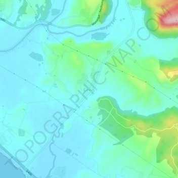
Name: Çavuş topographic map, elevation, terrain.
Location: Çavuş, Manavgat, Antalya, Mediterranean Region, 07610, Turkey (36.69486 31.58827 36.73486 31.62827)
Average elevation: 38 m
Minimum elevation: 0 m
Maximum elevation: 216 m
Thank you for supporting this site ❤️
Make a donation
Make a donation
Gear up for your next adventure:
As an Amazon Associate, this site earns from qualifying purchases at no extra cost to you.