Geolocate

Akseki topographic map

Click on the map to display elevation.

About this map

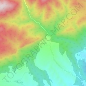
Name: Akseki topographic map, elevation, terrain.

Location: Akseki, Taşköprü, Kastamonu, Black Sea Region, Turkey (41.59856 34.18633 41.63856 34.22633)

Average elevation: 911 m

Minimum elevation: 655 m

Maximum elevation: 1,288 m

Gear up for your next adventure:

🌄Outdoor Binoculars - Compact binoculars for landscape observation
🧥Breathable Waterproof Jackets - Essential rain protection for the unpredictable British climate
🎒Backpack Rain Covers - Universal waterproof covers to protect your gear from downpours
📦Dry Bags - Waterproof bags to protect gear from rain
🛌Sleeping Mats - Insulated mats for comfortable outdoor sleeping

As an Amazon Associate, this site earns from qualifying purchases at no extra cost to you.