
Undangaon topographic map
Interactive map
Click on the map to display elevation.
About this map
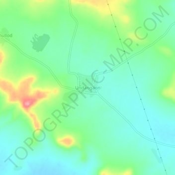
Name: Undangaon topographic map, elevation, terrain.
Location: Undangaon, Sillod, Aurangabad, Maharashtra, India (20.43562 75.64271 20.47562 75.68271)
Average elevation: 697 m
Minimum elevation: 665 m
Maximum elevation: 775 m
Other topographic maps
Click on a map to view its topography, its elevation and its terrain.
Bhawan
India > Maharashtra > Sillod
Bhawan, Sillod, Chhatrapati Sambhajinagar, Maharashtra, 431135, India
Average elevation: 596 m
Jalki Ghat
India > Maharashtra > Sillod
Jalki Ghat, Sillod, Aurangabad District, Maharashtra, 431113, India
Average elevation: 711 m
Khullod
India > Maharashtra > Sillod
Khullod, Sillod, Aurangabad, Maharashtra, India
Average elevation: 715 m
Gavhali Tanda
India > Maharashtra > Sillod
Gavhali Tanda, Sillod, Aurangabad, Maharashtra, India
Average elevation: 587 m