
Bridgeton topographic map
Interactive map
Click on the map to display elevation.
About this map
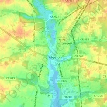
Name: Bridgeton topographic map, elevation, terrain.
Average elevation: 18 m
Minimum elevation: -3 m
Maximum elevation: 35 m
Other topographic maps
Click on a map to view its topography, its elevation and its terrain.
Maurice River
United States > New Jersey > Cumberland County
Maurice River, Cumberland County, New Jersey, United States
Average elevation: 17 m
Willis Corner
United States > New Jersey > Cumberland County > Stow Creek Township
Willis Corner, Stow Creek Township, Cumberland County, New Jersey, 08323, United States
Average elevation: 11 m
Garton
United States > New Jersey > Cumberland County > Deerfield Township
Garton, Deerfield Township, Cumberland County, New Jersey, 08352, United States
Average elevation: 31 m
Commercial Township
United States > New Jersey > Cumberland County
Commercial Township, Cumberland County, New Jersey, United States
Average elevation: 6 m
Vineland
United States > New Jersey > Cumberland County > Vineland
Vineland, Cumberland County, New Jersey, United States
Average elevation: 25 m
Greenwich
United States > New Jersey > Cumberland County > Greenwich Township > Greenwich
Greenwich, Greenwich Township, Cumberland County, New Jersey, 08323, United States
Average elevation: 2 m