Geolocate

Maurice River topographic map

Interactive map

Click on the map to display elevation.

About this map

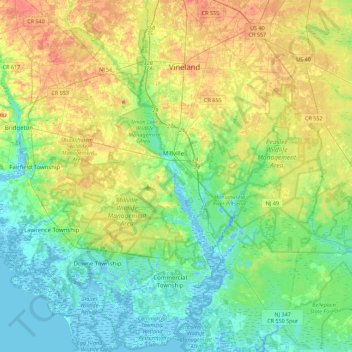
Name: Maurice River topographic map, elevation, terrain.

Location: Maurice River, Cumberland County, New Jersey, United States (39.20839 -75.08374 39.55100 -74.97832)

Average elevation: 17 m

Minimum elevation: -4 m

Maximum elevation: 45 m

Other topographic maps

Click on a map to view its topography, its elevation and its terrain.

Willis Corner

United States > New Jersey > Cumberland County > Stow Creek Township

Willis Corner, Stow Creek Township, Cumberland County, New Jersey, 08323, United States

Average elevation: 11 m

Garton

United States > New Jersey > Cumberland County > Deerfield Township

Garton, Deerfield Township, Cumberland County, New Jersey, 08352, United States

Average elevation: 31 m

Bridgeton

United States > New Jersey > Cumberland County

Bridgeton, Cumberland County, New Jersey, 08302, United States

Average elevation: 18 m

Commercial Township

United States > New Jersey > Cumberland County

Commercial Township, Cumberland County, New Jersey, United States

Average elevation: 6 m

Vineland

United States > New Jersey > Cumberland County > Vineland

Vineland, Cumberland County, New Jersey, United States

Average elevation: 25 m

Greenwich

United States > New Jersey > Cumberland County > Greenwich Township > Greenwich

Greenwich, Greenwich Township, Cumberland County, New Jersey, 08323, United States

Average elevation: 2 m