
Make a donation
Gear up for your next adventure:
As an Amazon Associate, this site earns from qualifying purchases at no extra cost to you.
Khoy topographic map
Click on the map to display elevation.
Make a donation
Gear up for your next adventure:
As an Amazon Associate, this site earns from qualifying purchases at no extra cost to you.
About this map
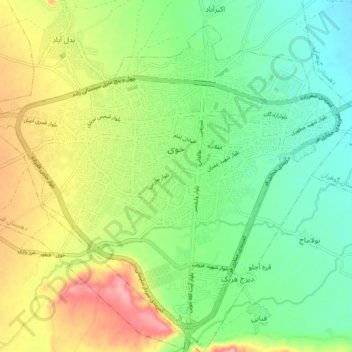
Name: Khoy topographic map, elevation, terrain.
Average elevation: 1,149 m
Minimum elevation: 1,090 m
Maximum elevation: 1,246 m
Make a donation
Gear up for your next adventure:
As an Amazon Associate, this site earns from qualifying purchases at no extra cost to you.
Other topographic maps
Click on a map to view its topography, its elevation and its terrain.
Bedelan
Iran > West Azerbaijan Province > Khoy County > دهستان فیرورق جنوبی
Average elevation: 1,708 m
Make a donation
Gear up for your next adventure:
As an Amazon Associate, this site earns from qualifying purchases at no extra cost to you.
Navai
Iran > West Azerbaijan Province > Khoy County > دهستان گوهران > Navai
Average elevation: 1,078 m