Geolocate

Northop topographic map

Click on the map to display elevation.

About this map

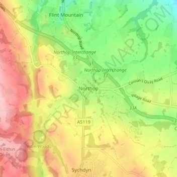
Name: Northop topographic map, elevation, terrain.

Location: Northop, Flintshire, Wales, CH7 6BH, United Kingdom (53.18679 -3.15246 53.22679 -3.11246)

Average elevation: 120 m

Minimum elevation: 34 m

Maximum elevation: 209 m

Flintshire trails, hiking, mountain biking, running and outdoor activities

Other topographic maps

Click on a map to view its topography, its elevation and its terrain.

Ewloe Castle

United Kingdom > Wales > Flintshire > Ewloe

Average elevation: 74 m

Penyffordd

United Kingdom > Wales > Flintshire

Average elevation: 101 m

Bagilt Reservior

United Kingdom > Wales > Flintshire > Bagillt

Average elevation: 32 m

Wepre Park

United Kingdom > Wales > Flintshire > Connah's Quay

Average elevation: 46 m

Saltney

United Kingdom > Wales > Flintshire

Average elevation: 9 m

Point of Ayr

United Kingdom > Wales > Flintshire > Talacre

Average elevation: 2 m

Nannerch

United Kingdom > Wales > Flintshire > Nannerch

Average elevation: 232 m

Gear up for your next adventure:

📍Handheld GPS Navigators - Reliable satellite navigation for hiking and off-road exploration
🥤Collapsible Water Bottles - Save space in your rucksack as you consume your water
🔥Emergency Fire Starters - Reliable ignition tools for survival situations in damp conditions
🔋Solar Chargers - Eco-friendly charging solutions for outdoor use
🛌Insulated Sleeping Mats - Crucial thermal protection when sleeping on cold, uneven ground

As an Amazon Associate, this site earns from qualifying purchases at no extra cost to you.