
Make a donation
Gear up for your next adventure:
As an Amazon Associate, this site earns from qualifying purchases at no extra cost to you.
Kinshasa topographic map
Click on the map to display elevation.
Make a donation
Gear up for your next adventure:
As an Amazon Associate, this site earns from qualifying purchases at no extra cost to you.
Kinshasa
Covering 9,965 square kilometers, Kinshasa stretches along the southern shores of the Pool Malebo, on the Congo River. It forms an expansive crescent across flat, low-lying terrain at an average altitude of about 300 meters. Situated between latitudes 4° and 5° and longitudes East 15° and 16°32, Kinshasa shares its borders with the Mai-Ndombe Province, Kwilu Province, and Kwango Province to the east; the Congo River delineates its western and northern perimeters, constituting a natural border with the Republic of the Congo; to the south lies the Kongo Central Province. Across the river sits Brazzaville, the smaller capital of the neighboring Republic of the Congo, forming the world's second-closest pair of capital cities despite being separated by a four-kilometer-wide unbridged span of the Congo River.
Make a donation
Gear up for your next adventure:
As an Amazon Associate, this site earns from qualifying purchases at no extra cost to you.
About this map
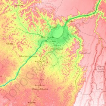
Name: Kinshasa topographic map, elevation, terrain.
Location: Kinshasa, Democratic Republic of the Congo (-5.03254 15.12706 -3.92761 16.53412)
Average elevation: 515 m
Minimum elevation: 198 m
Maximum elevation: 825 m
Make a donation
Gear up for your next adventure:
As an Amazon Associate, this site earns from qualifying purchases at no extra cost to you.
Other topographic maps
Click on a map to view its topography, its elevation and its terrain.
Make a donation
Gear up for your next adventure:
As an Amazon Associate, this site earns from qualifying purchases at no extra cost to you.
Make a donation
Gear up for your next adventure:
As an Amazon Associate, this site earns from qualifying purchases at no extra cost to you.
Kisangani
Democratic Republic of the Congo > Tshopo
The city is bordered by Banalia Territory to the north, Ubundu and Opala territories to the south, Isangi to the west, and Bafwasende municipalities to the east. Kisangani lies 324 km from Buta, 572 kilometres (355 mi) from Isiro, 696 kilometres (432 mi) from Bunia and 2,912 kilometres (1,809 mi) from…
Average elevation: 415 m
Mount Stanely
Democratic Republic of the Congo > North Kivu > Beni
Mount Stanley, also known as Mount Ngaliema (/əŋɡɑːˈljeɪmə/, also US: /-mɑː/, UK: /əŋˌɡɑːliˈeɪmə/), is a mountain located in the Rwenzori range. With an elevation of 5,109 m (16,763 ft), it is the highest mountain of both the Democratic Republic of the Congo and Uganda, and the fourth-highest in Africa.
Average elevation: 4,174 m
Make a donation
Gear up for your next adventure:
As an Amazon Associate, this site earns from qualifying purchases at no extra cost to you.
Make a donation
Gear up for your next adventure:
As an Amazon Associate, this site earns from qualifying purchases at no extra cost to you.
Make a donation
Gear up for your next adventure:
As an Amazon Associate, this site earns from qualifying purchases at no extra cost to you.
Nyiragongo
Democratic Republic of the Congo > North Kivu > Nyiragongo
Mount Nyiragongo (/ˌnɪərəˈɡɒŋɡoʊ, -ˈɡɔːŋ-/ neer-ə-GONG-go) is an active stratovolcano with an elevation of 3,470 m (11,385 ft) in the Virunga Mountains associated with the Albertine Rift. It is located inside Virunga National Park, in the Democratic Republic of the Congo, about 12 km (7.5 mi)…
Average elevation: 3,090 m
Make a donation
Gear up for your next adventure:
As an Amazon Associate, this site earns from qualifying purchases at no extra cost to you.
Make a donation
Gear up for your next adventure:
As an Amazon Associate, this site earns from qualifying purchases at no extra cost to you.
Lubumbashi
Democratic Republic of the Congo > Haut-Katanga > Ville de Lubumbashi > Lubumbashi
Average elevation: 1,250 m
Make a donation
Gear up for your next adventure:
As an Amazon Associate, this site earns from qualifying purchases at no extra cost to you.
Make a donation
Gear up for your next adventure:
As an Amazon Associate, this site earns from qualifying purchases at no extra cost to you.
Make a donation
Gear up for your next adventure:
As an Amazon Associate, this site earns from qualifying purchases at no extra cost to you.
Mbuji-Mayi
Democratic Republic of the Congo > Kasai-Oriental > Ville de Mbujimayi
Average elevation: 621 m
Make a donation
Gear up for your next adventure:
As an Amazon Associate, this site earns from qualifying purchases at no extra cost to you.
Make a donation
Gear up for your next adventure:
As an Amazon Associate, this site earns from qualifying purchases at no extra cost to you.
Make a donation
Gear up for your next adventure:
As an Amazon Associate, this site earns from qualifying purchases at no extra cost to you.
Make a donation
Gear up for your next adventure:
As an Amazon Associate, this site earns from qualifying purchases at no extra cost to you.
Make a donation
Gear up for your next adventure:
As an Amazon Associate, this site earns from qualifying purchases at no extra cost to you.
Make a donation
Gear up for your next adventure:
As an Amazon Associate, this site earns from qualifying purchases at no extra cost to you.
Make a donation
Gear up for your next adventure:
As an Amazon Associate, this site earns from qualifying purchases at no extra cost to you.
Make a donation
Gear up for your next adventure:
As an Amazon Associate, this site earns from qualifying purchases at no extra cost to you.
Kasaï-Oriental
Democratic Republic of the Congo > Kasai-Oriental > Ville de Mbujimayi
Average elevation: 621 m
Make a donation
Gear up for your next adventure:
As an Amazon Associate, this site earns from qualifying purchases at no extra cost to you.
Make a donation
Gear up for your next adventure:
As an Amazon Associate, this site earns from qualifying purchases at no extra cost to you.
Mount Stanely
Democratic Republic of the Congo > North Kivu > Beni
Mount Stanley, also known as Mount Ngaliema (/əŋɡɑːˈljeɪmə/, also US: /-mɑː/, UK: /əŋˌɡɑːliˈeɪmə/), is a mountain located in the Rwenzori range. With an elevation of 5,109 m (16,763 ft), it is the highest mountain of both the Democratic Republic of the Congo and Uganda, and the third highest…
Average elevation: 4,174 m
Make a donation
Gear up for your next adventure:
As an Amazon Associate, this site earns from qualifying purchases at no extra cost to you.
Make a donation
Gear up for your next adventure:
As an Amazon Associate, this site earns from qualifying purchases at no extra cost to you.
Nyiragongo
Democratic Republic of the Congo > North Kivu > Nyiragongo
Mount Nyiragongo is an active stratovolcano with an elevation of 3,470 m (11,380 ft) in the Virunga Mountains associated with the Albertine Rift. It is located inside Virunga National Park, in the Democratic Republic of the Congo, about 20 km (12 mi) north of the town of Goma and Lake Kivu and just west of the…
Average elevation: 3,090 m
Make a donation
Gear up for your next adventure:
As an Amazon Associate, this site earns from qualifying purchases at no extra cost to you.
Democratic Republic of the Congo
Democratic Republic of the Congo
The tropical climate also produced the Congo River system which dominates the region topographically along with the rainforest it flows through, though they are not mutually exclusive. The name for the Congo state is derived in part from the river. The river basin (meaning the Congo River and all of its myriad…
Average elevation: 717 m
Make a donation
Gear up for your next adventure:
As an Amazon Associate, this site earns from qualifying purchases at no extra cost to you.