
Nyiragongo topographic map
Interactive map
Click on the map to display elevation.
About this map
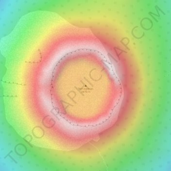
Name: Nyiragongo topographic map, elevation, terrain.
Average elevation: 3,090 m
Minimum elevation: 2,653 m
Maximum elevation: 3,449 m
Mount Nyiragongo is an active stratovolcano with an elevation of 3,470 m (11,380 ft) in the Virunga Mountains associated with the Albertine Rift. It is located inside Virunga National Park, in the Democratic Republic of the Congo, about 20 km (12 mi) north of the town of Goma and Lake Kivu and just west of the border with Rwanda. The main crater is about two kilometres wide and usually contains a lava lake. The crater presently has two distinct cooled lava benches within the crater walls – one at about 3,175 m (10,417 ft) and a lower one at about 2,975 m (9,760 ft). Nyiragongo's lava lake has at times been the most voluminous known lava lake in recent history. The depth of the lava lake varies considerably. A maximum elevation of the lava lake was recorded at about 3,250 m (10,660 ft) prior to the January 1977 eruption – a lake depth of about 600 m (2,000 ft). A recent very low elevation of the lava lake was recorded at about 2,700 m (8,900 ft). Nyiragongo and nearby Nyamuragira are together responsible for 40% of Africa's historical volcanic eruptions.
Other topographic maps
Click on a map to view its topography, its elevation and its terrain.
Butembo
Democratic Republic of the Congo > North Kivu > Butembo
Butembo, Kimeni, Butembo, North Kivu, Democratic Republic of the Congo
Average elevation: 1,763 m
Mulo
Democratic Republic of the Congo > North Kivu > Lubero
Mulo, Baswaga, Lubero, North Kivu, Democratic Republic of the Congo
Average elevation: 1,964 m
Goma
Democratic Republic of the Congo > North Kivu
Goma, North Kivu, Democratic Republic of the Congo
Average elevation: 1,613 m
Mavivi
Democratic Republic of the Congo > North Kivu > Beni
Mavivi, Beni, North Kivu, Democratic Republic of the Congo
Average elevation: 1,035 m
Vulamba
Democratic Republic of the Congo > North Kivu > Butembo
Vulamba, Butembo, North Kivu, Democratic Republic of the Congo
Average elevation: 1,804 m
Masisi
Democratic Republic of the Congo > North Kivu
Masisi, North Kivu, Democratic Republic of the Congo
Average elevation: 1,684 m
Kabati
Democratic Republic of the Congo > North Kivu
Kabati, North Kivu, Democratic Republic of the Congo
Average elevation: 1,860 m
Semliki
Democratic Republic of the Congo > North Kivu
Semliki, North Kivu, Democratic Republic of the Congo
Average elevation: 1,231 m
river
Democratic Republic of the Congo > North Kivu > Masisi
river, Bahunde, Masisi, North Kivu, Democratic Republic of the Congo
Average elevation: 1,824 m
Terrain
Democratic Republic of the Congo > North Kivu > Beni
Terrain, Beni, North Kivu, Democratic Republic of the Congo
Average elevation: 1,084 m
Mambia
Democratic Republic of the Congo > North Kivu > Lubero > Mambia
Mambia, Baswaga, Lubero, North Kivu, Democratic Republic of the Congo
Average elevation: 1,191 m
Lava Lake of Mount Nyiragongo
Democratic Republic of the Congo > North Kivu > Nyiragongo
Lava Lake of Mount Nyiragongo, Bukumu, Nyiragongo, North Kivu, Democratic Republic of the Congo
Average elevation: 3,084 m
Bulindi
Democratic Republic of the Congo > North Kivu > Rutshuru > Bulindi
Bulindi, Bwito, Rutshuru, North Kivu, Democratic Republic of the Congo
Average elevation: 1,669 m
Baruta
Democratic Republic of the Congo > North Kivu > Nyiragongo
Baruta, Bukumu, Nyiragongo, North Kivu, Democratic Republic of the Congo
Average elevation: 2,750 m
Goma
Democratic Republic of the Congo > North Kivu > Goma > Goma
Goma, Mabanga Nord, Karisimbi, Goma, North Kivu, 841, Democratic Republic of the Congo
Average elevation: 1,740 m
Rwindi River
Democratic Republic of the Congo > North Kivu
Rwindi River, Rutshuru, North Kivu, 256, Democratic Republic of the Congo
Average elevation: 1,203 m
Butembo
Democratic Republic of the Congo > North Kivu
Butembo, North Kivu, Democratic Republic of the Congo
Average elevation: 1,776 m
Nyiragongo
Democratic Republic of the Congo > North Kivu
Nyiragongo, North Kivu, Democratic Republic of the Congo
Average elevation: 1,960 m
Makerere
Democratic Republic of the Congo > North Kivu > Makerere
Makerere, Butembo, North Kivu, Democratic Republic of the Congo
Average elevation: 1,749 m
Lake Edward
Democratic Republic of the Congo > North Kivu > Lubero
Lake Edward, Lubero, North Kivu, Democratic Republic of the Congo
Average elevation: 1,132 m
Walikale
Democratic Republic of the Congo > North Kivu > Walikale
Walikale, North Kivu, Democratic Republic of the Congo
Average elevation: 746 m
Lubero
Democratic Republic of the Congo > North Kivu > Lubero
Lubero, North Kivu, Democratic Republic of the Congo
Average elevation: 979 m
Pinga
Democratic Republic of the Congo > North Kivu > Pinga
Pinga, North Kivu, Democratic Republic of the Congo
Average elevation: 1,045 m
Mumba
Democratic Republic of the Congo > North Kivu > Mumba
Mumba, Bahunde, Masisi, North Kivu, Democratic Republic of the Congo
Average elevation: 2,308 m
Oso
Democratic Republic of the Congo > North Kivu
Oso, Walikale, North Kivu, Democratic Republic of the Congo
Average elevation: 1,055 m
Beni
Democratic Republic of the Congo > North Kivu
Beni, North Kivu, Democratic Republic of the Congo
Average elevation: 1,296 m