
Make a donation
Gear up for your next adventure:
As an Amazon Associate, this site earns from qualifying purchases at no extra cost to you.
Goma topographic map
Click on the map to display elevation.
Make a donation
Gear up for your next adventure:
As an Amazon Associate, this site earns from qualifying purchases at no extra cost to you.
Goma
Köppen-Geiger climate classification system classifies Goma's climate as a tropical savanna climate (Aw). Goma is much milder than most climates of its latitude due to the city's high altitude, and sees warm days and pleasant nights year-round.
Make a donation
Gear up for your next adventure:
As an Amazon Associate, this site earns from qualifying purchases at no extra cost to you.
About this map
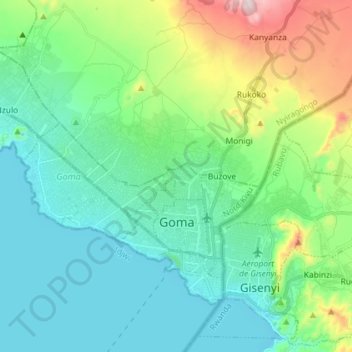
Name: Goma topographic map, elevation, terrain.
Location: Goma, North Kivu, Democratic Republic of the Congo (-1.70047 29.11525 -1.59510 29.26008)
Average elevation: 1,613 m
Minimum elevation: 1,454 m
Maximum elevation: 2,138 m
Make a donation
Gear up for your next adventure:
As an Amazon Associate, this site earns from qualifying purchases at no extra cost to you.
Other topographic maps
Click on a map to view its topography, its elevation and its terrain.
Nyiragongo
Democratic Republic of the Congo > North Kivu > Nyiragongo
Mount Nyiragongo (/ˌnɪərəˈɡɒŋɡoʊ, -ˈɡɔːŋ-/ neer-ə-GONG-go) is an active stratovolcano with an elevation of 3,470 m (11,385 ft) in the Virunga Mountains associated with the Albertine Rift. It is located inside Virunga National Park, in the Democratic Republic of the Congo, about 12 km (7.5 mi)…
Average elevation: 3,090 m
Make a donation
Gear up for your next adventure:
As an Amazon Associate, this site earns from qualifying purchases at no extra cost to you.
Mount Stanely
Democratic Republic of the Congo > North Kivu > Beni
Mount Stanley, also known as Mount Ngaliema (/əŋɡɑːˈljeɪmə/, also US: /-mɑː/, UK: /əŋˌɡɑːliˈeɪmə/), is a mountain located in the Rwenzori range. With an elevation of 5,109 m (16,763 ft), it is the highest mountain of both the Democratic Republic of the Congo and Uganda, and the third highest…
Average elevation: 4,174 m
Nyiragongo
Democratic Republic of the Congo > North Kivu > Nyiragongo
Mount Nyiragongo is an active stratovolcano with an elevation of 3,470 m (11,380 ft) in the Virunga Mountains associated with the Albertine Rift. It is located inside Virunga National Park, in the Democratic Republic of the Congo, about 20 km (12 mi) north of the town of Goma and Lake Kivu and just west of the…
Average elevation: 3,090 m
Make a donation
Gear up for your next adventure:
As an Amazon Associate, this site earns from qualifying purchases at no extra cost to you.
Make a donation
Gear up for your next adventure:
As an Amazon Associate, this site earns from qualifying purchases at no extra cost to you.
Make a donation
Gear up for your next adventure:
As an Amazon Associate, this site earns from qualifying purchases at no extra cost to you.
Mount Stanely
Democratic Republic of the Congo > North Kivu > Beni
Mount Stanley, also known as Mount Ngaliema (/əŋɡɑːˈljeɪmə/, also US: /-mɑː/, UK: /əŋˌɡɑːliˈeɪmə/), is a mountain located in the Rwenzori range. With an elevation of 5,109 m (16,763 ft), it is the highest mountain of both the Democratic Republic of the Congo and Uganda, and the fourth-highest in Africa.
Average elevation: 4,174 m
Make a donation
Gear up for your next adventure:
As an Amazon Associate, this site earns from qualifying purchases at no extra cost to you.
Make a donation
Gear up for your next adventure:
As an Amazon Associate, this site earns from qualifying purchases at no extra cost to you.