
Make a donation
Gear up for your next adventure:
As an Amazon Associate, this site earns from qualifying purchases at no extra cost to you.
Rhodope Mountains topographic map
Click on the map to display elevation.
Make a donation
Gear up for your next adventure:
As an Amazon Associate, this site earns from qualifying purchases at no extra cost to you.
Rhodope Mountains
In geomorphological terms, the Rhodopes are part of the Rila-Rhodope massif, which is the oldest landmass on the Balkan peninsula. The Rhodopes are spread over 14,735 square kilometers (5,689 sq mi), of which 12,233 square kilometers (4,723 sq mi) are on Bulgarian territory. They have the greatest extent of any single mountain range in Bulgaria. The mountains are about 240 kilometers (149 mi) long and about 100 to 120 kilometres (62 to 75 mi) wide, with an average altitude of 785 meters (2,575 ft). To the north the mountain slopes descend steeply towards the Upper Thracian Plain. To the west, the Rhodopes reach the Avram saddle, Yundola and the valley of the Mesta River. To the south and east they extend to the coastal plains of Greek Thrace. The Rhodopes are a complex system of ridges and deep river valleys.
Make a donation
Gear up for your next adventure:
As an Amazon Associate, this site earns from qualifying purchases at no extra cost to you.
About this map
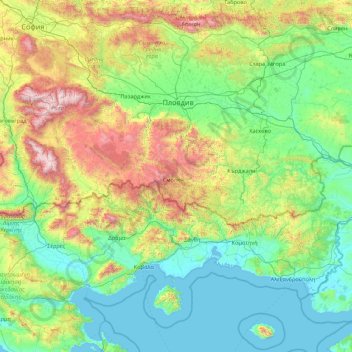
Name: Rhodope Mountains topographic map, elevation, terrain.
Location: Rhodope Mountains, Bulgaria (40.84291 23.03833 42.35246 26.49627)
Average elevation: 501 m
Minimum elevation: -3 m
Maximum elevation: 2,848 m
Make a donation
Gear up for your next adventure:
As an Amazon Associate, this site earns from qualifying purchases at no extra cost to you.
Other topographic maps
Click on a map to view its topography, its elevation and its terrain.
Sofia
Bulgaria > Sofia-City > Sredec
Sofia City Province has an area of 1344 km2, while the surrounding and much bigger Sofia Province is 7,059 km2. Sofia's development as a significant settlement owes much to its central position in the Balkans. It is situated in western Bulgaria, at the northern foot of the Vitosha mountain, in the Sofia Valley…
Average elevation: 746 m
Make a donation
Gear up for your next adventure:
As an Amazon Associate, this site earns from qualifying purchases at no extra cost to you.
Make a donation
Gear up for your next adventure:
As an Amazon Associate, this site earns from qualifying purchases at no extra cost to you.
Sofia
Bulgaria > Sofia-City > Sredec
Sofia City Province has an area of 1344 km2, while the surrounding and much bigger Sofia Province is 7,059 km2. Sofia's development as a significant settlement owes much to its central position in the Balkans. It is situated in western Bulgaria, at the northern foot of the Vitosha mountain, in the Sofia Valley…
Average elevation: 746 m
Make a donation
Gear up for your next adventure:
As an Amazon Associate, this site earns from qualifying purchases at no extra cost to you.
Rhodope Mountains
In geomorphological terms, the Rhodopes are part of the Rila-Rhodope massif, which is the oldest landmass on the Balkan peninsula. The Rhodopes are spread over 14,735 square kilometers (5,689 sq mi), of which 12,233 square kilometers (4,723 sq mi) are on Bulgarian territory. They have the greatest extent of…
Average elevation: 441 m
Vladaya
Bulgaria > Sofia-City > Vitosha
Vladaya (Bulgarian: Владая, pronounced [vɫɐˈdajɐ]) is a village on the Vitosha and Lyulin mountains in western Bulgaria at an altitude of about 1000 m. In the 2011 census in Vladaya were counted 4043 residents, which makes it the tenth largest village in Bulgaria. Administratively, it is part of the…
Average elevation: 1,038 m
Make a donation
Gear up for your next adventure:
As an Amazon Associate, this site earns from qualifying purchases at no extra cost to you.
Sofia
Bulgaria > Sofia-City > Sredec
Sofia City Province has an area of 1344 km2, while the surrounding and much bigger Sofia Province is 7,059 km2. Sofia's development as a significant settlement owes much to its central position in the Balkans. It is situated in western Bulgaria, at the northern foot of the Vitosha mountain, in the Sofia Valley…
Average elevation: 746 m
Make a donation
Gear up for your next adventure:
As an Amazon Associate, this site earns from qualifying purchases at no extra cost to you.
Make a donation
Gear up for your next adventure:
As an Amazon Associate, this site earns from qualifying purchases at no extra cost to you.
Bansko
Bansko (Bulgarian: Банско [ˈbansko]) is a town in southwestern Bulgaria, located at the foot of the Pirin Mountains at an elevation of 1200m above sea level. It is a ski resort.
Average elevation: 1,034 m
Make a donation
Gear up for your next adventure:
As an Amazon Associate, this site earns from qualifying purchases at no extra cost to you.
Sofia
Bulgaria > Sofia-City > Sredec
Sofia City Province has an area of 1344 km2, while the surrounding and much bigger Sofia Province is 7,059 km2. Sofia's development as a significant settlement owes much to its central position in the Balkans. It is situated in western Bulgaria, at the northern foot of the Vitosha mountain, in the Sofia Valley…
Average elevation: 746 m
Make a donation
Gear up for your next adventure:
As an Amazon Associate, this site earns from qualifying purchases at no extra cost to you.
Bankya
Bulgaria > Sofia-City > Bankia
Bankya is 17 km west of capital Sofia. It is situated at the foot of Lyulin Mountain at an average elevation of around 630–750 meters. The first people to populate the region of Bankya were Thracian tribes, over 2,500 years ago. Archaeological excavations near the quarter of Ivanyane have unearthed remains…
Average elevation: 743 m
Make a donation
Gear up for your next adventure:
As an Amazon Associate, this site earns from qualifying purchases at no extra cost to you.
Dospat
The town was probably founded by Despot Alexius Slav in the 12th or 13th century, from whose title (despot) its name is very likely derived. Dospat Dam is the highest dam in Bulgaria by altitude and, with its 22 km2 of water area, the second largest in capacity. It is fed by the River Dospat.
Average elevation: 1,304 m
Make a donation
Gear up for your next adventure:
As an Amazon Associate, this site earns from qualifying purchases at no extra cost to you.
Make a donation
Gear up for your next adventure:
As an Amazon Associate, this site earns from qualifying purchases at no extra cost to you.
Make a donation
Gear up for your next adventure:
As an Amazon Associate, this site earns from qualifying purchases at no extra cost to you.
Make a donation
Gear up for your next adventure:
As an Amazon Associate, this site earns from qualifying purchases at no extra cost to you.
Make a donation
Gear up for your next adventure:
As an Amazon Associate, this site earns from qualifying purchases at no extra cost to you.
Belmeken
Belmeken (Bulgarian: Белмекен) is a summit in the northeastern part of the Rila Mountain in southwestern Bulgaria with a height of 2,626 m. It is built up of granite. Its northern slopes are steep and rise over the Kutlinite cirque. The southern and southeastern slopes are oblique. To the southeast at…
Average elevation: 2,300 m
Make a donation
Gear up for your next adventure:
As an Amazon Associate, this site earns from qualifying purchases at no extra cost to you.
Vladaya
Bulgaria > Sofia-City > Vitosha
Vladaya (Bulgarian: Владая, pronounced [vɫɐˈdajɐ]) is a village on the Vitosha and Lyulin mountains in western Bulgaria at an altitude of about 1000 m. In the 2011 census in Vladaya were counted 4043 residents, which makes it the tenth largest village in Bulgaria.
Average elevation: 1,038 m
Make a donation
Gear up for your next adventure:
As an Amazon Associate, this site earns from qualifying purchases at no extra cost to you.
Make a donation
Gear up for your next adventure:
As an Amazon Associate, this site earns from qualifying purchases at no extra cost to you.
Bansko
Bansko lies at the foot of the Pirin Mountains, not far from the national park of the same name, in the valley of the Nestos River at an elevation of 925 meters above sea level. It is a ski resort. The city is about 160 km from Sofia and about 220 km from Thessaloniki.
Average elevation: 1,034 m
Sandanski
Sandanski has developed in an amphitheatrical fashion on the outer south-west flanks of Pirin Mountains along the lower reaches of Sandanska Bistritsa River. The town's altitude varies between 240 and 300 meters. Its geographical location between Kresna and Rupel Gorges determines the town's mild winter and…
Average elevation: 276 m
Make a donation
Gear up for your next adventure:
As an Amazon Associate, this site earns from qualifying purchases at no extra cost to you.
Make a donation
Gear up for your next adventure:
As an Amazon Associate, this site earns from qualifying purchases at no extra cost to you.
Make a donation
Gear up for your next adventure:
As an Amazon Associate, this site earns from qualifying purchases at no extra cost to you.
Balkan Mountains
The park's herpetofauna includes 15 reptile and nine amphibian species. It hosts vital populations of common European adder (Vipera berus), European toad, grass snake (Natrix natrix), legless lizard, tessellated water snake, viviparous lizard and the common frog. Due to the park's high altitude, the…
Average elevation: 538 m
Make a donation
Gear up for your next adventure:
As an Amazon Associate, this site earns from qualifying purchases at no extra cost to you.
Bansko
Bansko lies at the foot of the Pirin Mountains, not far from the national park of the same name, in the valley of the Nestos River at an elevation of 925 meters above sea level. It is a ski resort. The city is about 160 km from Sofia and about 220 km from Thessaloniki.
Average elevation: 1,034 m
Make a donation
Gear up for your next adventure:
As an Amazon Associate, this site earns from qualifying purchases at no extra cost to you.
Make a donation
Gear up for your next adventure:
As an Amazon Associate, this site earns from qualifying purchases at no extra cost to you.
Ruse
Ruse is on the right bank of the river Danube, which is the high bank, having two underwater terraces and three river terraces at 15 to 22 m (49.21–72.18 ft), 30 to 66 m (98.43–216.54 ft), and 54 to 65 m (177.17–213.25 ft). The average altitude is 45.5 m (149.28 ft) AMSL. The urban area is an…
Average elevation: 72 m
Make a donation
Gear up for your next adventure:
As an Amazon Associate, this site earns from qualifying purchases at no extra cost to you.