
Arzúa topographic map
Interactive map
Click on the map to display elevation.
About this map
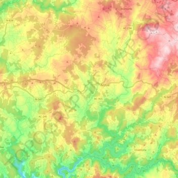
Name: Arzúa topographic map, elevation, terrain.
Location: Arzúa, Corunha, Galiza, Espanha (42.84287 -8.30090 43.00472 -8.06397)
Average elevation: 369 m
Minimum elevation: 156 m
Maximum elevation: 615 m
Other topographic maps
Click on a map to view its topography, its elevation and its terrain.