
Ash Shalif topographic map
Interactive map
Click on the map to display elevation.
About this map
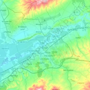
Name: Ash Shalif topographic map, elevation, terrain.
Location: Ash Shalif, Chlef District, Chlef, 02000, Algeria (36.09029 1.25950 36.24885 1.44872)
Average elevation: 179 m
Minimum elevation: 76 m
Maximum elevation: 522 m
Chlef lies in a valley at an elevation of 114 metres (374 ft) between two ranges of hills to the north and west. The city is surrounded by farmland; there are scattered trees both in the valley and on the hills.
Other topographic maps
Click on a map to view its topography, its elevation and its terrain.
Sendjas
Algeria > Chlef > Chlef District > Sendjas
Sendjas, Chlef District, Chlef, 02025, Algeria
Average elevation: 388 m