
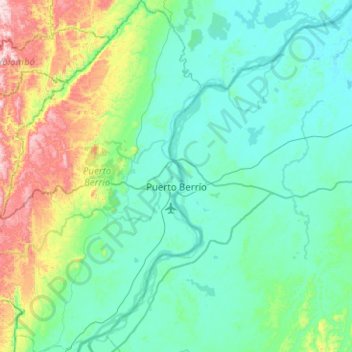
Puerto Berrío topographic map
Interactive map
Click on the map to display elevation.
About this map
Name: Puerto Berrío topographic map, elevation, terrain.
Average elevation: 210 m
Minimum elevation: 81 m
Maximum elevation: 791 m
Other topographic maps
Click on a map to view its topography, its elevation and its terrain.
Medellín
Colombia > Antioquia > Medellín
Medellín has 16 comunas (districts), 5 corregimientos (townships), and 271 barrios (neighborhoods). The metropolitan area of Medellín lies within the Aburrá valley at an elevation of 1,500 metres (4,900 feet) above sea level and is bisected by the Medellín River (also called Porce), which flows northward.…
Average elevation: 2,098 m
Andes
Andes is a municipality and town in the Antioquia Department, Colombia. Part of the sub-region of Southwestern Antioquia, it is located on the western Colombian Andes mountain range. Andes was founded on 13 March 1852 by Pedro Antonio Restrepo Escobar. Its elevation is 1,360 metres above sea level with an…
Average elevation: 1,559 m
Caucasia
Colombia > Antioquia > Caucasia
The municipality of Caucasia is located at the northern department of Antioquia, on the border with the department of Córdoba and the subregion of Bajo Cauca Antioquia. It lies at an altitude of 150 m (490 ft) above sea level. Its territory is a flat area with small ridges in the north and west and south. It…
Average elevation: 63 m
Rionegro
Colombia > Antioquia > Rionegro
The city of Rionegro is located at 6°9′18″N 75°22′48″W / 6.15500°N 75.38000°W / 6.15500; -75.38000, at an average elevation of 2,125 metres (6,972 ft) above sea level. The average annual precipitation varies between 1,800 and 2,500 millimetres (71 and 98 in) with an average temperature of…
Average elevation: 2,232 m
Andes
Andes is a municipality and town in the Antioquia Department, Colombia. Part of the sub-region of Southwestern Antioquia, it is located on the western Colombian Andes mountain range. Andes was founded on 13 March 1852 by Pedro Antonio Restrepo Escobar. Its elevation is 1,360 metres above sea level with an…
Average elevation: 1,559 m
Támesis
Colombia > Antioquia > Támesis
Támesis is a town and municipality in the Colombian department of Antioquia. Part of the subregion of Southwestern Antioquia. Located at an elevation of 1,638 m (5,374 ft) above sea level, it was established in 1858. The local economy is based on agriculture.
Average elevation: 1,718 m
Caucasia
Colombia > Antioquia > Caucasia
The municipality of Caucasia is located at the northern department of Antioquia, on the border with the department of Córdoba and the subregion of Bajo Cauca Antioquia. It lies at an altitude of 150 m (490 ft) above sea level. Its territory is a flat area with small ridges in the north and west and south. It…
Average elevation: 63 m
Campamento
Colombia > Antioquia > Campamento
Campamento is a town and municipality in the Colombian department of Antioquia. Part of the subregion of Northern Antioquia, it lies at an altitude of 1,700 m (5,600 ft) above sea level. It is a little town, in the middle of the Andes.It borders on the north with the municipalities of Yarumal and Anorí, on…
Average elevation: 1,607 m
Sabaneta
Colombia > Antioquia > Sabaneta
Its topography varies from flat reliefs and slight hills to places with steep slopes. Its most notable heights are those of Piedras Blancas (2,650 mamsl) in La Romera, the Cuchilla Santa Teresa (2,200 mamsl), the hill of Los Gallinazos in Pan de Azúcar (1,800 mamsl), the hill Morrón, La Siberia and the Ancón.
Average elevation: 1,787 m
Caucasia
Colombia > Antioquia > Caucasia
The municipality of Caucasia is located at the northern department of Antioquia, on the border with the department of Córdoba and the subregion of Bajo Cauca Antioquia. It lies at an altitude of 150 m (490 ft) above sea level. Its territory is a flat area with small ridges in the north and west and south. It…
Average elevation: 63 m
Rionegro
Colombia > Antioquia > Rionegro
The city of Rionegro is located at 6°9′18″N 75°22′48″W / 6.15500°N 75.38000°W / 6.15500; -75.38000, at an average elevation of 2,125 metres above sea level. The average annual precipitation varies between 1,800 and 2,500 millimeters with an average temperature of 17 °C. Much of the land…
Average elevation: 2,232 m