
Irkutsk Oblast topographic map
Interactive map
Click on the map to display elevation.
About this map
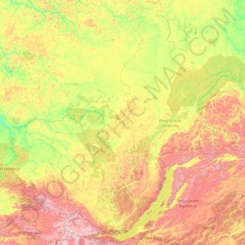
Name: Irkutsk Oblast topographic map, elevation, terrain.
Location: Irkutsk Oblast, Siberian Federal District, Russia (51.12989 95.64627 64.32155 119.13931)
Average elevation: 620 m
Minimum elevation: 77 m
Maximum elevation: 3,123 m
Other topographic maps
Click on a map to view its topography, its elevation and its terrain.
Ural Mountains
Russia > Khanty-Mansiysk Autonomous Okrug – Ugra > Beryozovsky District
The Ural Mountains (/ˈjʊərəl/ YOOR-əl; Russian: Ура́льские го́ры, tr. Uralskiye gory, IPA: [ʊˈralʲskʲɪjə ˈɡorɨ]; Bashkir: Урал тауҙары) or simply the Urals, are a mountain range in Eurasia that runs north-south mostly through Russia, from the coast of the Arctic Ocean to…
Average elevation: 1,435 m
Sochi
Russia > Krasnodar Krai > Resort Town of Sochi (municipal formation)
Sochi has a humid subtropical climate (Köppen climate classification Cfa), at the lower elevations. Its average annual temperature is 18.9 °C (66.0 °F) during the day and 11.5 °C (52.7 °F) at night. In the coldest months—January and February—the average temperature is about 10 °C (50 °F) during the…
Average elevation: 148 m
Siberia
Russia > Krasnoyarsk Krai > Boguchansky Rayon
Eastern and central Sakha comprises numerous north–south mountain ranges of various ages. These mountains extend up to almost 3,000 metres (9,800 ft), but above a few hundred metres they are almost completely devoid of vegetation. The Verkhoyansk Range was extensively glaciated in the Pleistocene, but the…
Average elevation: 346 m
Пырьях
Russia > Khanty-Mansiysk Autonomous Okrug – Ugra > Khanty-Mansiysky District
Average elevation: 29 m
Oymyakon
Russia > Sakha Republic > Oymyakonsky Ulus
With an extreme subarctic climate (Köppen climate classification Dfd, Trewartha climate classification Ecle), Oymyakon is known as one of the places considered the Northern Pole of Cold, the other being the town of Verkhoyansk, located 629 km (391 mi) away by air. The weather station is in a valley between…
Average elevation: 679 m
Dyatlov-rock
Russia > Sverdlovsk Oblast > Ивдельский муниципальный округ
Diaries and cameras found around their last campsite made it possible to track the group's route up to the day preceding the incident. On January 31, the group arrived at the edge of a highland area and began to prepare for climbing. In a wooded valley, they cached surplus food and equipment that would be used…
Average elevation: 755 m
Большая Тонга
Russia > Sverdlovsk Oblast > Североуральский муниципальный округ
Average elevation: 294 m
Dyatlov Pine gorge
Russia > Sverdlovsk Oblast > Ивдельский муниципальный округ
Diaries and cameras found around their last campsite made it possible to track the group's route up to the day preceding the incident. On January 31, the group arrived at the edge of a highland area and began to prepare for climbing. In a wooded valley, they cached surplus food and equipment that would be used…
Average elevation: 742 m