Geolocate

Treherbert topographic map

Click on the map to display elevation.

About this map

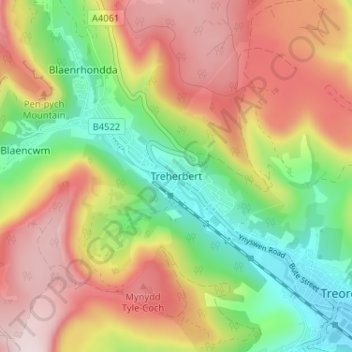
Name: Treherbert topographic map, elevation, terrain.

Location: Treherbert, Rhondda Cynon Taf, Wales, CF42 5PT, United Kingdom (51.65437 -3.55513 51.69437 -3.51513)

Average elevation: 345 m

Minimum elevation: 159 m

Maximum elevation: 544 m

Rhondda Cynon Taf trails, hiking, mountain biking, running and outdoor activities

Other topographic maps

Click on a map to view its topography, its elevation and its terrain.

Pontypridd

United Kingdom > Wales > Rhondda Cynon Taf

Average elevation: 183 m

Trealaw

United Kingdom > Wales > Rhondda Cynon Taf > Tonypandy

Average elevation: 222 m

Mid Glamorgan

United Kingdom > Wales > Rhondda Cynon Taf

Average elevation: 235 m

Penrhiwceiber

United Kingdom > Wales > Rhondda Cynon Taf

Average elevation: 229 m

Pontypridd

United Kingdom > Wales > Rhondda Cynon Taf

Average elevation: 183 m

Gear up for your next adventure:

👕Technical Hiking Tees - Moisture-management for high-exertion climbs
🪓Outdoor Multitools - Versatile tools for hiking and camping
🧼Biodegradable Soap - Leave-no-trace hygiene for multi-day mountain treks
🥼Base Layers - Thermal base layers for temperature regulation
❄️Walking Crampons - Added traction for icy slopes and winter peak bagging

As an Amazon Associate, this site earns from qualifying purchases at no extra cost to you.