Geolocate

Grimsby topographic map

Interactive map

Click on the map to display elevation.

About this map

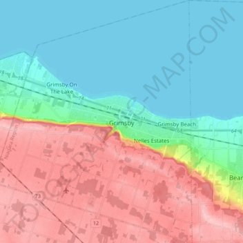
Name: Grimsby topographic map, elevation, terrain.

Location: Grimsby, Niagara Region, Golden Horseshoe, Ontario, Canada (43.13259 -79.64968 43.25484 -79.51193)

Average elevation: 127 m

Minimum elevation: 73 m

Maximum elevation: 213 m

Other topographic maps

Click on a map to view its topography, its elevation and its terrain.

Horseshoe Falls

Canada > Ontario > Niagara Region > Niagara Falls

Average elevation: 174 m

St. Catharines

Canada > Ontario > Niagara Region

The most defining transportation icon of St. Catharines is the Welland Canal, a ship canal that runs 43.4 kilometres (27.0 mi), passing through the city. Four of its locks are within city boundaries. The canal allows shipping vessels to traverse the 99.5-metre (326.5 ft) drop in altitude from Lake Erie to Lake…

Average elevation: 103 m

Welland

Canada > Ontario > Niagara Region

Average elevation: 182 m

Niagara River

Canada > Ontario > Niagara Region > Niagara Falls

The river, which is occasionally described as a strait, is about 58 kilometres (36 mi) long and includes Niagara Falls in its course. The falls have moved approximately 11 kilometres (6.8 mi) upstream from the Niagara Escarpment in the last 12,000 years, resulting in a gorge below the falls. Today, the…

Average elevation: 177 m

Port Colborne

Canada > Ontario > Niagara Region

Average elevation: 177 m

Fonthill

Canada > Ontario > Niagara Region

Average elevation: 193 m

Bal Harbour

Canada > Ontario > Niagara Region > Grimsby

Average elevation: 83 m

Niagara Falls

Canada > Ontario > Niagara Region

Average elevation: 179 m

Niagara-on-the-Lake

Canada > Ontario > Niagara Region

Average elevation: 108 m

Thorold

Canada > Ontario > Niagara Region

Average elevation: 175 m

Pelham

Canada > Ontario > Niagara Region > Pelham

From the top of the Fonthill Kame Delta hill, a unique topographical feature (Ontario Geological Society 1970) and ANSI protected site (Area of Natural Scientific Interest - ANSI) on a clear day it is possible to see Toronto, Hamilton and western New York state. At one time, a ski tow was installed on the…

Average elevation: 183 m

Ridgeway

Canada > Ontario > Niagara Region > Fort Erie

Average elevation: 184 m

Wainfleet

Canada > Ontario > Niagara Region

Average elevation: 179 m