
New London topographic map
Interactive map
Click on the map to display elevation.
About this map
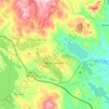
Name: New London topographic map, elevation, terrain.
Location: New London, Merrimack County, New Hampshire, United States (43.38012 -72.05798 43.46493 -71.90704)
Average elevation: 365 m
Minimum elevation: 213 m
Maximum elevation: 604 m
Other topographic maps
Click on a map to view its topography, its elevation and its terrain.
Wilmot
United States > New Hampshire > Merrimack County
Mount Kearsarge, elevation 2,931 feet (893 m) above sea level, on the southern border, is the highest point in town and in Merrimack County. Winslow State Park, at the northern foot of the mountain, provides access by two hiking trails to the summit. The state park and the Winslow Trail are named after Captain…
Average elevation: 364 m
Warner
United States > New Hampshire > Merrimack County
Mount Kearsarge, elevation 2,937 feet (895 m) above sea level, located in the extreme north of the town, is the highest point in Warner and in Merrimack County. Two state parks are located on the mountain: Rollins State Park in Warner and Winslow State Park in Wilmot. Mount Kearsarge is a popular hiking…
Average elevation: 247 m
Henniker
United States > New Hampshire > Merrimack County
Craney Hill, elevation 1,402 feet (427 m) above sea level and home of the Pats Peak ski area, is in the south. The highest point in Henniker is an unnamed summit near the town's northwest corner, with an elevation of 1,552 ft (473 m).
Average elevation: 223 m
Andover
United States > New Hampshire > Merrimack County > Andover
According to the United States Census Bureau, the town has a total area of 41.4 square miles (107.3 km2), of which 40.5 sq mi (105.0 km2) is land and 0.89 sq mi (2.3 km2) is water, comprising 2.14% of the town. Andover is drained by the Blackwater River. Bradley Lake is in the south. Ragged Mountain, elevation…
Average elevation: 301 m
Pembroke
United States > New Hampshire > Merrimack County
According to the United States Census Bureau, the town has a total area of 23.0 square miles (59.6 km2), of which 22.8 sq mi (59.1 km2) is land and 0.2 sq mi (0.5 km2) is water, comprising 0.70% of the town. Pembroke is drained by the Suncook, Soucook and Merrimack rivers. The highest point in town, Plausawa…
Average elevation: 131 m
Rings Corner
United States > New Hampshire > Merrimack County > Pittsfield > Rings Corner
Average elevation: 190 m
Hopkinton
United States > New Hampshire > Merrimack County
According to the United States Census Bureau, the town has a total area of 45.1 square miles (116.8 km2), of which 43.3 square miles (112.1 km2) are land and 1.8 square miles (4.6 km2) are water, comprising 3.97% of the town. Hopkinton is drained by the Contoocook River and its tributary, the Warner River,…
Average elevation: 146 m