
Reckange topographic map
Interactive map
Click on the map to display elevation.
About this map
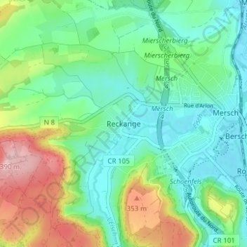
Name: Reckange topographic map, elevation, terrain.
Location: Reckange, Mersch, Canton Mersch, 7595, Luxembourg (49.72893 6.06107 49.76893 6.10107)
Average elevation: 271 m
Minimum elevation: 215 m
Maximum elevation: 400 m
Other topographic maps
Click on a map to view its topography, its elevation and its terrain.
Hollenfels
Luxembourg > Canton Mersch > Helperknapp
Hollenfels, Helperknapp, Canton Mersch, 7435, Luxembourg
Average elevation: 327 m