
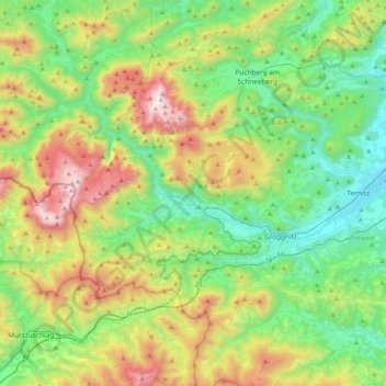
Rax-Schneeberg Group topographic map
Interactive map
Click on the map to display elevation.
About this map
Name: Rax-Schneeberg Group topographic map, elevation, terrain.
Average elevation: 909 m
Minimum elevation: 380 m
Maximum elevation: 2,065 m
The highest point in the limestone massif of the Schneeberg is the Klosterwappen at 2,076 m above sea level (AA). Its nearby twin peak is known as the Kaiserstein (2,061 m above sea level (AA)). The two summits are the highest mountains in the state of Lower Austria. The highest two elevations in the Rax massif are the Heukuppe at 2,007 m and the Scheibwaldhöhe at 1,943 m.
Other topographic maps
Click on a map to view its topography, its elevation and its terrain.
Gemeinde Schottwien
Austria > Lower Austria > Bezirk Neunkirchen
Gemeinde Schottwien, Bezirk Neunkirchen, Lower Austria, 2641, Austria
Average elevation: 941 m
Gemeinde Payerbach
Austria > Lower Austria > Bezirk Neunkirchen
Gemeinde Payerbach, Bezirk Neunkirchen, Lower Austria, Austria
Average elevation: 770 m
Klosterwappen
Austria > Lower Austria > Bezirk Neunkirchen > Gemeinde Reichenau an der Rax
Klosterwappen, Gemeinde Reichenau an der Rax, Bezirk Neunkirchen, Lower Austria, Austria
Average elevation: 1,715 m
Gemeinde Ternitz
Austria > Lower Austria > Bezirk Neunkirchen
Gemeinde Ternitz, Bezirk Neunkirchen, Lower Austria, Austria
Average elevation: 512 m
Sonnleiten
Austria > Lower Austria > Bezirk Neunkirchen > Gemeinde Schwarzau im Gebirge
Sonnleiten, Gemeinde Schwarzau im Gebirge, Bezirk Neunkirchen, Lower Austria, 2661, Austria
Average elevation: 872 m
Gemeinde Willendorf
Austria > Lower Austria > Bezirk Neunkirchen > Gemeinde Willendorf
Gemeinde Willendorf, Bezirk Neunkirchen, Lower Austria, 2732, Austria
Average elevation: 418 m