
Eisenstadt topographic map
Interactive map
Click on the map to display elevation.
About this map
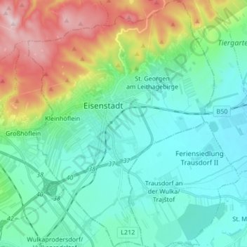
Name: Eisenstadt topographic map, elevation, terrain.
Location: Eisenstadt, Burgenland, Austria (47.79349 16.48384 47.88397 16.58554)
Average elevation: 220 m
Minimum elevation: 131 m
Maximum elevation: 478 m
Other topographic maps
Click on a map to view its topography, its elevation and its terrain.
Leitha Mountains
Austria > Burgenland > Eisenstadt
Leitha Mountains, Eisenstadt, Burgenland, 7082, Austria
Average elevation: 187 m