
Leitha Mountains topographic map
Interactive map
Click on the map to display elevation.
About this map
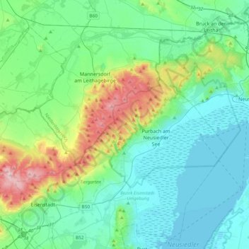
Name: Leitha Mountains topographic map, elevation, terrain.
Location: Leitha Mountains, Eisenstadt, Burgenland, 7082, Austria (47.83701 16.44375 48.01565 16.81983)
Average elevation: 187 m
Minimum elevation: 110 m
Maximum elevation: 478 m
Other topographic maps
Click on a map to view its topography, its elevation and its terrain.