Geolocate

Waymart topographic map

Click on the map to display elevation.

About this map

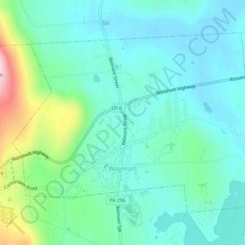
Name: Waymart topographic map, elevation, terrain.

Location: Waymart, Wayne County, Pennsylvania, 18472, United States (41.57500 -75.42638 41.59788 -75.38499)

Average elevation: 451 m

Minimum elevation: 390 m

Maximum elevation: 659 m

Other topographic maps

Click on a map to view its topography, its elevation and its terrain.

Gouldsboro

United States > Pennsylvania > Wayne County

Average elevation: 589 m

West Hawley

United States > Pennsylvania > Wayne County > Hawley

Average elevation: 346 m

Beach Lake

United States > Pennsylvania > Wayne County

Average elevation: 393 m

Newfoundland

United States > Pennsylvania > Wayne County

Average elevation: 456 m

Hamlin

United States > Pennsylvania > Wayne County

Average elevation: 459 m

Lake Ariel

United States > Pennsylvania > Wayne County

Average elevation: 453 m

Milanville

United States > Pennsylvania > Wayne County

Average elevation: 298 m

Gear up for your next adventure:

📱Rugged Phone Cases - Heavy-duty protection for smartphones used as secondary GPS tools
👟Women's Trail Running Shoes - Agile footwear for fell running and technical trails
🔦Outdoor Torches - Reliable torches for night navigation
👖Packable Overtrousers - Quick-deploy rain protection for legs in sudden storms
❄️Walking Crampons - Added traction for icy slopes and winter peak bagging

As an Amazon Associate, this site earns from qualifying purchases at no extra cost to you.