
Make a donation
Gear up for your next adventure:
As an Amazon Associate, this site earns from qualifying purchases at no extra cost to you.
Lake Ariel topographic map
Click on the map to display elevation.
Make a donation
Gear up for your next adventure:
As an Amazon Associate, this site earns from qualifying purchases at no extra cost to you.
About this map
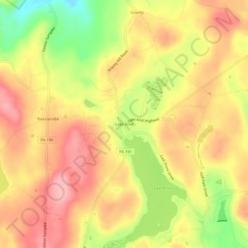
Name: Lake Ariel topographic map, elevation, terrain.
Average elevation: 453 m
Minimum elevation: 365 m
Maximum elevation: 510 m
Make a donation
Gear up for your next adventure:
As an Amazon Associate, this site earns from qualifying purchases at no extra cost to you.
Other topographic maps
Click on a map to view its topography, its elevation and its terrain.
Make a donation
Gear up for your next adventure:
As an Amazon Associate, this site earns from qualifying purchases at no extra cost to you.
Hawley
United States > Pennsylvania > Wayne County
Hawley is located where Middle Creek enters the Lackawaxen River, at 41°28′42″N 75°10′45″W / 41.47833°N 75.17917°W / 41.47833; -75.17917 (41.478225, -75.179154) at an elevation of 1,033 feet (314.9 m). Hawley students attend Wallenpaupack Areas Schools, with high, middle, and primary…
Average elevation: 334 m
Make a donation
Gear up for your next adventure:
As an Amazon Associate, this site earns from qualifying purchases at no extra cost to you.
Make a donation
Gear up for your next adventure:
As an Amazon Associate, this site earns from qualifying purchases at no extra cost to you.
Make a donation
Gear up for your next adventure:
As an Amazon Associate, this site earns from qualifying purchases at no extra cost to you.