Geolocate

Dixie topographic map

Click on the map to display elevation.

About this map

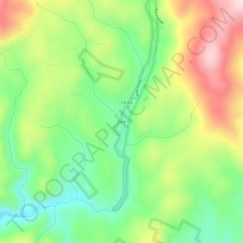
Name: Dixie topographic map, elevation, terrain.

Location: Dixie, Idaho County, Idaho, United States (45.53407 -115.48124 45.57407 -115.44124)

Average elevation: 1,781 m

Minimum elevation: 1,630 m

Maximum elevation: 1,992 m

Other topographic maps

Click on a map to view its topography, its elevation and its terrain.

Elk City

United States > Idaho > Idaho County

Average elevation: 1,348 m

White Bird

United States > Idaho > Idaho County

Average elevation: 637 m

Big Mallard Creek

United States > Idaho > Idaho County

Average elevation: 1,718 m

Antler Ridge

United States > Idaho > Idaho County

Average elevation: 1,292 m

Royal Gorge

United States > Idaho > Idaho County

Average elevation: 681 m

Grangeville

United States > Idaho > Idaho County

Average elevation: 1,037 m

Riggins

United States > Idaho > Idaho County

Riggins is a city in the western United States in Idaho County, Idaho. Nestled deep in a canyon at the confluence of the Salmon and Little Salmon rivers in west central Idaho, it is approximately 150 highway miles (240 km) north of Boise, and 120 highway miles (190 km) south-southeast of Lewiston. The…

Average elevation: 706 m

Dry Can Creek

United States > Idaho > Idaho County

Average elevation: 1,163 m

Gear up for your next adventure:

🍲Portable Camping Stoves - Fast-boiling stoves for hot meals on remote topographic survey trips
🗺️Ordnance Survey Maps - Official UK maps for walking and outdoor activities
🔋Solar Power Banks - Keep your GPS and phone charged during multi-day expeditions
📐Altimeters & Barometers - Tools for measuring altitude and air pressure
🥾Walking Shoes - Lightweight walking shoes for countryside and coastal paths

As an Amazon Associate, this site earns from qualifying purchases at no extra cost to you.