
Make a donation
Gear up for your next adventure:
As an Amazon Associate, this site earns from qualifying purchases at no extra cost to you.
Lescheret topographic map
Click on the map to display elevation.
Make a donation
Gear up for your next adventure:
As an Amazon Associate, this site earns from qualifying purchases at no extra cost to you.
About this map
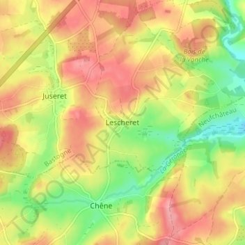
Name: Lescheret topographic map, elevation, terrain.
Average elevation: 457 m
Minimum elevation: 404 m
Maximum elevation: 500 m
Make a donation
Gear up for your next adventure:
As an Amazon Associate, this site earns from qualifying purchases at no extra cost to you.
Other topographic maps
Click on a map to view its topography, its elevation and its terrain.
Vielsalm
Belgique > Luxembourg > Bastogne
L’altitude la plus haute est donc de 652 mètres(Baraque de Fraiture)alors que son altitude la plus basse est de 294 mètres(Grand-Halleux). Son altitude moyenne est alors de 473 mètres au-dessus du niveau de la mer.
Average elevation: 473 m
Bastogne
Belgique > Luxembourg > Bastogne
Bastogne est située en Ardenne belge, dans l'est de la province de Luxembourg à 12 km de la frontière luxembourgeoise, à 515 m d'altitude sur la ligne de crête qui sépare les bassins versants du Rhin et de la Meuse. Elle est la 9e commune de Belgique par superficie et la troisième de la province (après…
Average elevation: 464 m
Make a donation
Gear up for your next adventure:
As an Amazon Associate, this site earns from qualifying purchases at no extra cost to you.
Gouvy
Belgique > Luxembourg > Bastogne
La commune de Gouvy a une altitude moyenne de 488,25 m. Son point le plus haut se situe entre Langlire et Lomré et est à 592,5 m d’altitude. Son point le plus bas se situe à Rettigny avec 384 m d’altitude.
Average elevation: 483 m
Make a donation
Gear up for your next adventure:
As an Amazon Associate, this site earns from qualifying purchases at no extra cost to you.
Vielsalm
Belgique > Luxembourg > Bastogne
L’altitude la plus haute est donc de 652 mètres (Baraque de Fraiture) alors que son altitude la plus basse est de 294 mètres (Grand-Halleux). Son altitude moyenne est alors de 473 mètres.
Average elevation: 473 m
Make a donation
Gear up for your next adventure:
As an Amazon Associate, this site earns from qualifying purchases at no extra cost to you.
Make a donation
Gear up for your next adventure:
As an Amazon Associate, this site earns from qualifying purchases at no extra cost to you.
Make a donation
Gear up for your next adventure:
As an Amazon Associate, this site earns from qualifying purchases at no extra cost to you.
Make a donation
Gear up for your next adventure:
As an Amazon Associate, this site earns from qualifying purchases at no extra cost to you.
Make a donation
Gear up for your next adventure:
As an Amazon Associate, this site earns from qualifying purchases at no extra cost to you.
Make a donation
Gear up for your next adventure:
As an Amazon Associate, this site earns from qualifying purchases at no extra cost to you.
Make a donation
Gear up for your next adventure:
As an Amazon Associate, this site earns from qualifying purchases at no extra cost to you.
Make a donation
Gear up for your next adventure:
As an Amazon Associate, this site earns from qualifying purchases at no extra cost to you.
Make a donation
Gear up for your next adventure:
As an Amazon Associate, this site earns from qualifying purchases at no extra cost to you.
Make a donation
Gear up for your next adventure:
As an Amazon Associate, this site earns from qualifying purchases at no extra cost to you.
Gouvy
Belgique > Luxembourg > Bastogne
La commune de Gouvy a une altitude moyenne de 488,25 m. Son point le plus haut se situe entre Langlire et Lomré et est à 592,5 m d’altitude. Son point le plus bas se situe à Rettigny avec 384 m d’altitude.
Average elevation: 483 m
Bastogne
Belgique > Luxembourg > Bastogne
Bastogne est située en Ardenne belge, dans l'est de la province de Luxembourg à 12 km de la frontière luxembourgeoise, à 515 m d'altitude sur la ligne de crête qui sépare les bassins versants du Rhin et de la Meuse. Elle est la 9e commune de Belgique par superficie et la troisième de la province (après…
Average elevation: 464 m
Bastogne
Belgique > Luxembourg > Bastogne
La commune de Bastogne est située en Ardenne belge, dans l'est de la province de Luxembourg, frontalière du Luxembourg (le centre-ville étant à 12 km de la frontière luxembourgeoise), à 515 m d'altitude sur la ligne de crête qui sépare les bassins versants du Rhin et de la Meuse. Avec ses 264,69…
Average elevation: 464 m
Make a donation
Gear up for your next adventure:
As an Amazon Associate, this site earns from qualifying purchases at no extra cost to you.
Vielsalm
Belgique > Luxembourg > Bastogne
L’altitude la plus haute est donc de 652 mètres (Baraque de Fraiture) alors que son altitude la plus basse est de 294 mètres (Grand-Halleux). Son altitude moyenne est alors de 473 mètres.
Average elevation: 473 m
Make a donation
Gear up for your next adventure:
As an Amazon Associate, this site earns from qualifying purchases at no extra cost to you.
Bastogne
Belgique > Luxembourg > Bastogne
La commune de Bastogne est située en Ardenne belge, dans l'est de la province de Luxembourg, frontalière du Luxembourg (le centre-ville étant à 12 km de la frontière luxembourgeoise), à 515 m d'altitude sur la ligne de crête qui sépare les bassins versants du Rhin et de la Meuse. Avec ses 264,69 km2,…
Average elevation: 464 m
Make a donation
Gear up for your next adventure:
As an Amazon Associate, this site earns from qualifying purchases at no extra cost to you.
Make a donation
Gear up for your next adventure:
As an Amazon Associate, this site earns from qualifying purchases at no extra cost to you.
Bastogne
Belgique > Luxembourg > Bastogne
Bastogne est située en Ardenne belge, dans l'est de la province de Luxembourg à 12 km de la frontière luxembourgeoise, à 515 m d'altitude sur la ligne de crête qui sépare les bassins versants du Rhin et de la Meuse. Elle est la 9e commune de Belgique par superficie et la troisième de la province (après…
Average elevation: 464 m