
Kamphaeng Phet Province topographic map
Interactive map
Click on the map to display elevation.
About this map
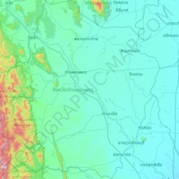
Name: Kamphaeng Phet Province topographic map, elevation, terrain.
Location: Kamphaeng Phet Province, Thailand (15.85679 98.98636 16.88889 100.03305)
Average elevation: 162 m
Minimum elevation: 27 m
Maximum elevation: 1,861 m
Other topographic maps
Click on a map to view its topography, its elevation and its terrain.
Ban Khlong Suk Chai
Thailand > Kamphaeng Phet Province
Ban Khlong Suk Chai, Thung Sai, Kamphaeng Phet Province, Thailand
Average elevation: 55 m
Ban Nam Dip
Thailand > Kamphaeng Phet Province > Ban Nam Dip
Ban Nam Dip, Nong Pling, Kamphaeng Phet Province, Thailand
Average elevation: 94 m