
Make a donation
Gear up for your next adventure:
As an Amazon Associate, this site earns from qualifying purchases at no extra cost to you.
Utsjoki topographic map
Click on the map to display elevation.
Make a donation
Gear up for your next adventure:
As an Amazon Associate, this site earns from qualifying purchases at no extra cost to you.
Utsjoki
The Utsjoki region is flatter and lower in altitudes than many others. Large areas of Utsjoki are less than 300 m above sea level. Many fjell summits are less than 500 m high. In general, the topography is smooth and the fjells slope gently. The summits are very flat and large in area as is typical of old peneplain surfaces.
Make a donation
Gear up for your next adventure:
As an Amazon Associate, this site earns from qualifying purchases at no extra cost to you.
About this map
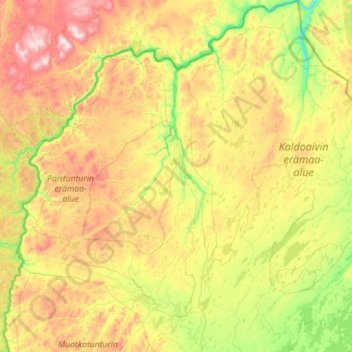
Name: Utsjoki topographic map, elevation, terrain.
Location: Utsjoki, Northern Lapland, Lapland, Mainland Finland, Finland (69.14758 25.69274 70.09229 28.34527)
Average elevation: 291 m
Minimum elevation: 0 m
Maximum elevation: 1,029 m
Make a donation
Gear up for your next adventure:
As an Amazon Associate, this site earns from qualifying purchases at no extra cost to you.
Other topographic maps
Click on a map to view its topography, its elevation and its terrain.
Make a donation
Gear up for your next adventure:
As an Amazon Associate, this site earns from qualifying purchases at no extra cost to you.
Make a donation
Gear up for your next adventure:
As an Amazon Associate, this site earns from qualifying purchases at no extra cost to you.
Kilpisjärvi
Although Kilpisjärvi is one of the largest villages in Enontekiö, it is still quite small. In 2000 its population was recorded as 114. Like most Sami villages, Kilpisjärvi is built mainly around one major road, Käsivarrentie, or the "Arm Road" and Neljäntuulentie, or the "Four Winds' Road" — also known…
Average elevation: 527 m
Make a donation
Gear up for your next adventure:
As an Amazon Associate, this site earns from qualifying purchases at no extra cost to you.
Make a donation
Gear up for your next adventure:
As an Amazon Associate, this site earns from qualifying purchases at no extra cost to you.
Make a donation
Gear up for your next adventure:
As an Amazon Associate, this site earns from qualifying purchases at no extra cost to you.
Make a donation
Gear up for your next adventure:
As an Amazon Associate, this site earns from qualifying purchases at no extra cost to you.