
Bollnäs kommun topographic map
Interactive map
Click on the map to display elevation.
About this map
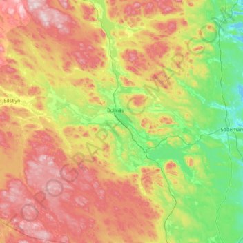
Name: Bollnäs kommun topographic map, elevation, terrain.
Location: Bollnäs kommun, Provincia de Gävleborg, Suecia (60.99206 15.92162 61.64444 16.74763)
Average elevation: 189 m
Minimum elevation: -1 m
Maximum elevation: 514 m
Other topographic maps
Click on a map to view its topography, its elevation and its terrain.
Gästrike-Hammarby
Suecia > Provincia de Gävleborg
Gästrike-Hammarby, Sandvikens kommun, Provincia de Gävleborg, Suecia
Average elevation: 78 m
Tosås
Suecia > Provincia de Gävleborg
Tosås, Nordanstigs kommun, Provincia de Gävleborg, Suecia
Average elevation: 224 m