
Tosås topographic map
Interactive map
Click on the map to display elevation.
About this map
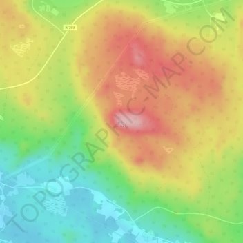
Name: Tosås topographic map, elevation, terrain.
Location: Tosås, Nordanstigs kommun, Provincia de Gävleborg, Suecia (62.11183 16.77552 62.11193 16.77562)
Average elevation: 224 m
Minimum elevation: 138 m
Maximum elevation: 316 m
Other topographic maps
Click on a map to view its topography, its elevation and its terrain.
Gästrike-Hammarby
Suecia > Provincia de Gävleborg
Gästrike-Hammarby, Sandvikens kommun, Provincia de Gävleborg, Suecia
Average elevation: 78 m
Bollnäs kommun
Suecia > Provincia de Gävleborg
Bollnäs kommun, Provincia de Gävleborg, Suecia
Average elevation: 189 m