
Make a donation
Gear up for your next adventure:
As an Amazon Associate, this site earns from qualifying purchases at no extra cost to you.
Clonmany topographic map
Click on the map to display elevation.
Make a donation
Gear up for your next adventure:
As an Amazon Associate, this site earns from qualifying purchases at no extra cost to you.
Clonmany
The village claims to be the youngest in Inishowen. The 18th century travel writer - Richard Pococke - did not mention the village when he toured the area in 1752. The village is mentioned in Topographia Hibernica, published in 1795. It did not feature in the census of 1841 or 1851. In the 1861 census, 112 inhabitants are recorded as living in Clonmany in 21 houses. A further 3 houses are recorded as uninhabited.
Make a donation
Gear up for your next adventure:
As an Amazon Associate, this site earns from qualifying purchases at no extra cost to you.
About this map
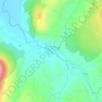
Name: Clonmany topographic map, elevation, terrain.
Average elevation: 47 m
Minimum elevation: 0 m
Maximum elevation: 168 m
Make a donation
Gear up for your next adventure:
As an Amazon Associate, this site earns from qualifying purchases at no extra cost to you.
Other topographic maps
Click on a map to view its topography, its elevation and its terrain.
Make a donation
Gear up for your next adventure:
As an Amazon Associate, this site earns from qualifying purchases at no extra cost to you.
Make a donation
Gear up for your next adventure:
As an Amazon Associate, this site earns from qualifying purchases at no extra cost to you.
Make a donation
Gear up for your next adventure:
As an Amazon Associate, this site earns from qualifying purchases at no extra cost to you.