
Riesbach topographic map
Interactive map
Click on the map to display elevation.
About this map
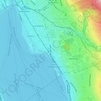
Name: Riesbach topographic map, elevation, terrain.
Location: Riesbach, Zürich, Bezirk Zürich, Zürich, 8008, Schweiz (47.34087 8.54204 47.36602 8.58628)
Average elevation: 441 m
Minimum elevation: 402 m
Maximum elevation: 617 m
Other topographic maps
Click on a map to view its topography, its elevation and its terrain.
Aussichtsturm Oerlikon (Blauer Turm)
Aussichtsturm Oerlikon (Blauer Turm), Armin-Bollinger-Weg, Oerlikon, Kreis 11, Zürich, Bezirk Zürich, Zürich, 8052, Schweiz
Average elevation: 456 m
Irchelpark
Irchelpark, Unterstrass, Kreis 6, Zürich, Bezirk Zürich, Zürich, Schweiz
Average elevation: 489 m
Aussersihl
Aussersihl, Zürich, Bezirk Zürich, Zürich, Schweiz
Average elevation: 418 m
Industriequartier
Industriequartier, Zürich, Bezirk Zürich, Zürich, 8005, Schweiz
Average elevation: 428 m
Ruine Manegg
Ruine Manegg, Maneggweg, Leimbach, Kreis 2, Zürich, Bezirk Zürich, Zürich, 8041, Schweiz
Average elevation: 561 m