
Aussichtsturm Oerlikon (Blauer Turm) topographic map
Interactive map
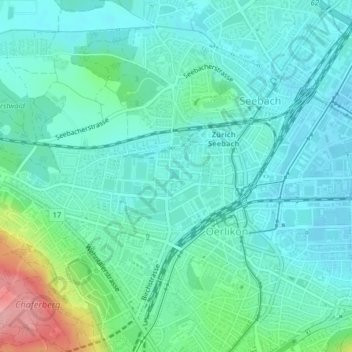
Click on the map to display elevation.
About this map
Name: Aussichtsturm Oerlikon (Blauer Turm) topographic map, elevation, terrain.
Average elevation: 456 m
Minimum elevation: 426 m
Maximum elevation: 566 m
Der aus Beton erstellte Turm ist 35,50 Meter hoch, die Aussichtsplattform befindet sich in 33 Meter Höhe und wurde am 2001 eingeweiht. Der ganze Turm ist mit einem feinmaschigen Stahlnetz umhüllt.
Other topographic maps
Click on a map to view its topography, its elevation and its terrain.
Irchelpark
Irchelpark, Unterstrass, Kreis 6, Zürich, Bezirk Zürich, Zürich, Schweiz
Average elevation: 489 m
Aussersihl
Aussersihl, Zürich, Bezirk Zürich, Zürich, Schweiz
Average elevation: 418 m
Industriequartier
Industriequartier, Zürich, Bezirk Zürich, Zürich, 8005, Schweiz
Average elevation: 428 m
Ruine Manegg
Ruine Manegg, Maneggweg, Leimbach, Kreis 2, Zürich, Bezirk Zürich, Zürich, 8041, Schweiz
Average elevation: 561 m