
Pontevedra topographic map
Interactive map
Click on the map to display elevation.
About this map
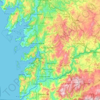
Name: Pontevedra topographic map, elevation, terrain.
Location: Pontevedra, Galicia, España (41.86393 -8.94963 42.86016 -7.86143)
Average elevation: 339 m
Minimum elevation: -2 m
Maximum elevation: 1,399 m
Other topographic maps
Click on a map to view its topography, its elevation and its terrain.
Villalba
España > Galicia > Tierra Chá
Villalba, Tierra Chá, Lugo, Galicia, España
Average elevation: 509 m
Camariñas
España > Galicia > Tierra de Soneira
Camariñas, Tierra de Soneira, La Coruña, Galicia, 15123, España
Average elevation: 33 m
Monte de Guilán
Monte de Guilán, Xove, Mariña Occidental, Lugo, Galicia, 27863, España
Average elevation: 248 m