
Make a donation
Gear up for your next adventure:
As an Amazon Associate, this site earns from qualifying purchases at no extra cost to you.
la Roca del Vallès topographic map
Click on the map to display elevation.
Make a donation
Gear up for your next adventure:
As an Amazon Associate, this site earns from qualifying purchases at no extra cost to you.
About this map
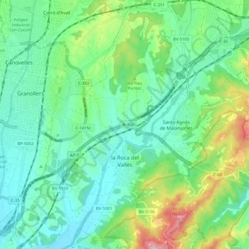
Name: la Roca del Vallès topographic map, elevation, terrain.
Average elevation: 187 m
Minimum elevation: 92 m
Maximum elevation: 456 m
Make a donation
Gear up for your next adventure:
As an Amazon Associate, this site earns from qualifying purchases at no extra cost to you.
Other topographic maps
Click on a map to view its topography, its elevation and its terrain.
Corró d'Amunt
Spain > Catalonia > Vallès Oriental > les Franqueses del Vallès
Average elevation: 287 m
les Agudes
Spain > Catalonia > Vallès Oriental > Montseny
Les Agudes is a mountain of Catalonia, Spain. It has an elevation of 1,706 metres (5,597 ft) above sea level. It is straddling the municipalities of Arbúcies in the Selva comarca and Fogars de Montclús and Montseny in the Vallès Oriental.
Average elevation: 1,288 m
Make a donation
Gear up for your next adventure:
As an Amazon Associate, this site earns from qualifying purchases at no extra cost to you.