
Make a donation
Gear up for your next adventure:
As an Amazon Associate, this site earns from qualifying purchases at no extra cost to you.
Bechena topographic map
Click on the map to display elevation.
Make a donation
Gear up for your next adventure:
As an Amazon Associate, this site earns from qualifying purchases at no extra cost to you.
Bechena
Bichena (Amharic: ብቸና) is a town in northern Ethiopia. Located in the Misraq Gojjam Zone of the Amhara Region on the hillside overlooking the Abay River, it has a latitude and longitude of 10°27′N 38°12′E / 10.450°N 38.200°E / 10.450; 38.200 and an elevation of 2541 meters above sea level. It is the administrative center of Enemay woreda.
Make a donation
Gear up for your next adventure:
As an Amazon Associate, this site earns from qualifying purchases at no extra cost to you.
About this map
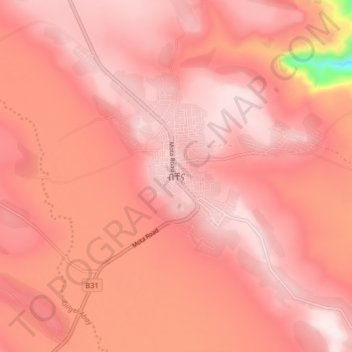
Name: Bechena topographic map, elevation, terrain.
Location: Bechena, East Gojjam, Amhara Region, 1221, Ethiopia (10.40806 38.16171 10.48806 38.24171)
Average elevation: 2,461 m
Minimum elevation: 2,042 m
Maximum elevation: 2,578 m
Make a donation
Gear up for your next adventure:
As an Amazon Associate, this site earns from qualifying purchases at no extra cost to you.
Other topographic maps
Click on a map to view its topography, its elevation and its terrain.
Germama/kesem
The Germama is not a navigable stream, and flows with a great volume during the rainy season. It rises west of Kese Koremash, flowing east to the Awash, its course delineating a few kilometers of the northern boundary of the Awash National Park. The Kessem River passes an altitude drop from more than 2000 m on…
Average elevation: 1,306 m
Make a donation
Gear up for your next adventure:
As an Amazon Associate, this site earns from qualifying purchases at no extra cost to you.