
Make a donation
Gear up for your next adventure:
As an Amazon Associate, this site earns from qualifying purchases at no extra cost to you.
Dejen topographic map
Click on the map to display elevation.
Make a donation
Gear up for your next adventure:
As an Amazon Associate, this site earns from qualifying purchases at no extra cost to you.
About this map
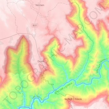
Name: Dejen topographic map, elevation, terrain.
Location: Dejen, East Gojjam, Amhara Region, Ethiopia (10.01934 38.04698 10.34676 38.31044)
Average elevation: 1,902 m
Minimum elevation: 1,002 m
Maximum elevation: 2,587 m
Make a donation
Gear up for your next adventure:
As an Amazon Associate, this site earns from qualifying purchases at no extra cost to you.
Other topographic maps
Click on a map to view its topography, its elevation and its terrain.
Dessie
Dessie (Amharic: ደሴ, romanized: Däse; also spelled Dese or Dessye) is a town in north-central Ethiopia. Located in the South Wollo Zone of the Amhara Region, it sits at a latitude and longitude of 11°8′N 39°38′E / 11.133°N 39.633°E / 11.133; 39.633, with an elevation between 2,470 and…
Average elevation: 2,450 m
Make a donation
Gear up for your next adventure:
As an Amazon Associate, this site earns from qualifying purchases at no extra cost to you.
Bechena
Bichena (Amharic: ብቸና) is a town in northern Ethiopia. Located in the Misraq Gojjam Zone of the Amhara Region on the hillside overlooking the Abay River, it has a latitude and longitude of 10°27′N 38°12′E / 10.450°N 38.200°E / 10.450; 38.200 and an elevation of 2541 meters above sea…
Average elevation: 2,461 m
Make a donation
Gear up for your next adventure:
As an Amazon Associate, this site earns from qualifying purchases at no extra cost to you.
Kamisee
Kemise (Oromo: Kamisee; Amharic: ከሚሴ) is a town and administrative seat of the Oromia Zone in the Amhara Region, Ethiopia. Kemise is 224 kilometres (139 mi) northeast of the Ethiopian capital, Addis Ababa and has a latitude and longitude of 10°43′N 39°52′E / 10.717°N 39.867°E / 10.717;…
Average elevation: 1,494 m
Make a donation
Gear up for your next adventure:
As an Amazon Associate, this site earns from qualifying purchases at no extra cost to you.
Make a donation
Gear up for your next adventure:
As an Amazon Associate, this site earns from qualifying purchases at no extra cost to you.
Bati
Bati (Oromo: Baati; Amharic: ባቲ) is a town in north-central Ethiopia. Located in the Oromia Zone of the Amhara Region, east of Dessie this town has a latitude and longitude of 11°11′N 40°1′E / 11.183°N 40.017°E / 11.183; 40.017 with an elevation of 1502 metres above sea level. It is the…
Average elevation: 1,450 m
Make a donation
Gear up for your next adventure:
As an Amazon Associate, this site earns from qualifying purchases at no extra cost to you.
Germama/kesem
The Germama is not a navigable stream, and flows with a great volume during the rainy season. It rises west of Kese Koremash, flowing east to the Awash, its course delineating a few kilometers of the northern boundary of the Awash National Park. The Kessem River passes an altitude drop from more than 2000 m on…
Average elevation: 1,306 m
Make a donation
Gear up for your next adventure:
As an Amazon Associate, this site earns from qualifying purchases at no extra cost to you.
Make a donation
Gear up for your next adventure:
As an Amazon Associate, this site earns from qualifying purchases at no extra cost to you.
Make a donation
Gear up for your next adventure:
As an Amazon Associate, this site earns from qualifying purchases at no extra cost to you.