
Make a donation
Gear up for your next adventure:
As an Amazon Associate, this site earns from qualifying purchases at no extra cost to you.
Dessie topographic map
Click on the map to display elevation.
Make a donation
Gear up for your next adventure:
As an Amazon Associate, this site earns from qualifying purchases at no extra cost to you.
Dessie
Dessie (Amharic: ደሴ, romanized: Däse; also spelled Dese or Dessye) is a town in north-central Ethiopia. Located in the South Wollo Zone of the Amhara Region, it sits at a latitude and longitude of 11°8′N 39°38′E / 11.133°N 39.633°E / 11.133; 39.633, with an elevation between 2,470 and 2,550 metres above sea level. Dessie is 400 km to the north of the capital Addis Ababa. It has a population of more than 200,000 people in over 30 wards.
Make a donation
Gear up for your next adventure:
As an Amazon Associate, this site earns from qualifying purchases at no extra cost to you.
About this map
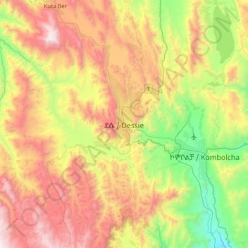
Name: Dessie topographic map, elevation, terrain.
Location: Dessie, South Wollo, Amhara Region, Ethiopia (10.96260 39.47498 11.28260 39.79498)
Average elevation: 2,450 m
Minimum elevation: 1,582 m
Maximum elevation: 3,506 m
Make a donation
Gear up for your next adventure:
As an Amazon Associate, this site earns from qualifying purchases at no extra cost to you.
Other topographic maps
Click on a map to view its topography, its elevation and its terrain.
Germama/kesem
The Germama is not a navigable stream, and flows with a great volume during the rainy season. It rises west of Kese Koremash, flowing east to the Awash, its course delineating a few kilometers of the northern boundary of the Awash National Park. The Kessem River passes an altitude drop from more than 2000 m on…
Average elevation: 1,306 m
Make a donation
Gear up for your next adventure:
As an Amazon Associate, this site earns from qualifying purchases at no extra cost to you.
Lake Tana
Lake Tana (Amharic: ጣና ሐይቅ, romanized: T’ana ḥāyik’i; previously Tsana) is the largest lake in Ethiopia and the source of the Blue Nile. Located in Amhara Region in the north-western Ethiopian Highlands, the lake is approximately 84 kilometres (52 miles) long and 66 kilometres (41 miles) wide,…
Average elevation: 1,829 m
Make a donation
Gear up for your next adventure:
As an Amazon Associate, this site earns from qualifying purchases at no extra cost to you.