
Make a donation
Gear up for your next adventure:
As an Amazon Associate, this site earns from qualifying purchases at no extra cost to you.
Lake Tana topographic map
Click on the map to display elevation.
Make a donation
Gear up for your next adventure:
As an Amazon Associate, this site earns from qualifying purchases at no extra cost to you.
Lake Tana
Lake Tana (Amharic: ጣና ሐይቅ, romanized: T’ana ḥāyik’i; previously Tsana) is the largest lake in Ethiopia and the source of the Blue Nile. Located in Amhara Region in the north-western Ethiopian Highlands, the lake is approximately 84 kilometres (52 miles) long and 66 kilometres (41 miles) wide, with a maximum depth of 15 metres (49 feet), and an elevation of 1,788 metres (5,866 feet). Lake Tana is fed by the Gilgel Abay, Reb and Gumara rivers. Its surface area ranges from 3,000 to 3,500 square kilometres (1,200 to 1,400 square miles), depending on season and rainfall. The lake level has been regulated since the construction of the control weir where the lake discharges into the Blue Nile. This controls the flow to the Blue Nile Falls (Tis Abbai) and hydro-power station.
Make a donation
Gear up for your next adventure:
As an Amazon Associate, this site earns from qualifying purchases at no extra cost to you.
About this map
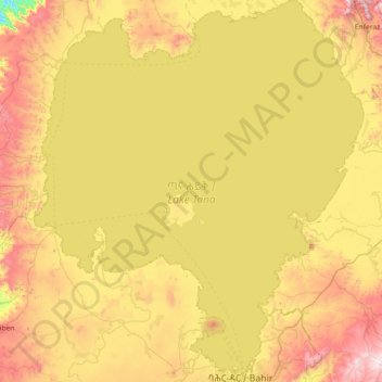
Name: Lake Tana topographic map, elevation, terrain.
Location: Lake Tana, Amhara Region, Ethiopia (11.59643 36.99544 12.30510 37.62224)
Average elevation: 1,829 m
Minimum elevation: 1,376 m
Maximum elevation: 2,394 m
Make a donation
Gear up for your next adventure:
As an Amazon Associate, this site earns from qualifying purchases at no extra cost to you.
Other topographic maps
Click on a map to view its topography, its elevation and its terrain.
Make a donation
Gear up for your next adventure:
As an Amazon Associate, this site earns from qualifying purchases at no extra cost to you.
Kamisee
Kemise (Oromo: Kamisee; Amharic: ከሚሴ) is a town and administrative seat of the Oromia Zone in the Amhara Region, Ethiopia. Kemise is 224 kilometres (139 mi) northeast of the Ethiopian capital, Addis Ababa and has a latitude and longitude of 10°43′N 39°52′E / 10.717°N 39.867°E / 10.717;…
Average elevation: 1,494 m
Make a donation
Gear up for your next adventure:
As an Amazon Associate, this site earns from qualifying purchases at no extra cost to you.
Bechena
Bichena (Amharic: ብቸና) is a town in northern Ethiopia. Located in the Misraq Gojjam Zone of the Amhara Region on the hillside overlooking the Abay River, it has a latitude and longitude of 10°27′N 38°12′E / 10.450°N 38.200°E / 10.450; 38.200 and an elevation of 2541 meters above sea…
Average elevation: 2,461 m
Make a donation
Gear up for your next adventure:
As an Amazon Associate, this site earns from qualifying purchases at no extra cost to you.
Dessie
Dessie (Amharic: ደሴ, romanized: Däse; also spelled Dese or Dessye) is a town in north-central Ethiopia. Located in the South Wollo Zone of the Amhara Region, it sits at a latitude and longitude of 11°8′N 39°38′E / 11.133°N 39.633°E / 11.133; 39.633, with an elevation between 2,470 and…
Average elevation: 2,450 m
Make a donation
Gear up for your next adventure:
As an Amazon Associate, this site earns from qualifying purchases at no extra cost to you.
Bati
Bati (Oromo: Baati; Amharic: ባቲ) is a town in north-central Ethiopia. Located in the Oromia Zone of the Amhara Region, east of Dessie this town has a latitude and longitude of 11°11′N 40°1′E / 11.183°N 40.017°E / 11.183; 40.017 with an elevation of 1502 metres above sea level. It is the…
Average elevation: 1,450 m
Make a donation
Gear up for your next adventure:
As an Amazon Associate, this site earns from qualifying purchases at no extra cost to you.
Germama/kesem
The Germama is not a navigable stream, and flows with a great volume during the rainy season. It rises west of Kese Koremash, flowing east to the Awash, its course delineating a few kilometers of the northern boundary of the Awash National Park. The Kessem River passes an altitude drop from more than 2000 m on…
Average elevation: 1,306 m
Make a donation
Gear up for your next adventure:
As an Amazon Associate, this site earns from qualifying purchases at no extra cost to you.
Make a donation
Gear up for your next adventure:
As an Amazon Associate, this site earns from qualifying purchases at no extra cost to you.
Make a donation
Gear up for your next adventure:
As an Amazon Associate, this site earns from qualifying purchases at no extra cost to you.