
Ilanz/Glion topographic map
Interactive map
Click on the map to display elevation.
About this map
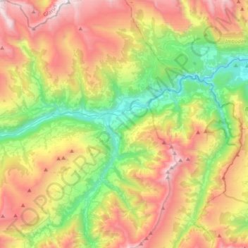
Name: Ilanz/Glion topographic map, elevation, terrain.
Location: Ilanz/Glion, Surselva, Graubünden, Schweiz (46.65650 9.06554 46.87539 9.29625)
Average elevation: 1,613 m
Minimum elevation: 603 m
Maximum elevation: 2,996 m
Other topographic maps
Click on a map to view its topography, its elevation and its terrain.
Burgruine Löwenstein
Schweiz > Graubünden > Ilanz/Glion
Burgruine Löwenstein, Stradun Cantunal, Ilanz/Glion, Surselva, Graubünden, 7130, Schweiz
Average elevation: 861 m