Geolocate

Baja topographic map

Interactive map

Click on the map to display elevation.

About this map

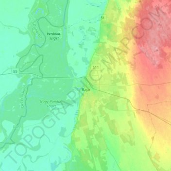
Name: Baja topographic map, elevation, terrain.

Location: Baja, Bajai járás, Bács-Kiskun, South Great Plain, Great Plain and North, Hungary (46.12542 18.82208 46.24076 19.14008)

Average elevation: 106 m

Minimum elevation: 80 m

Maximum elevation: 166 m

Other topographic maps

Click on a map to view its topography, its elevation and its terrain.

Harta

Hungary > Bács-Kiskun

Average elevation: 95 m

Dunapataj

Hungary > Bács-Kiskun

Average elevation: 95 m

Zab-szék

Hungary > Bács-Kiskun > Szabadszállás

Average elevation: 93 m

Kecskemét

Hungary > Bács-Kiskun

Kecskemét was established at the meeting point of a large sandy region and a sandy yellow soil; its elevation is 120 m (394 ft) above sea level. The territory west of the city is covered by wind-blown sand, characterised by the almost parallel northern-southern sand dunes and the plain between them. At the…

Average elevation: 116 m

Kalocsa

Hungary > Bács-Kiskun

Average elevation: 91 m

Golgota

Hungary > Bács-Kiskun > Lajosmizse

Average elevation: 136 m

Bajai járás

Hungary > Bács-Kiskun

Average elevation: 111 m

Lajosmizse

Hungary > Bács-Kiskun > Lajosmizse

Average elevation: 133 m

Dunafalva

Hungary > Bács-Kiskun > Dunafalva > Dunafalva

Average elevation: 97 m