
Make a donation
Gear up for your next adventure:
As an Amazon Associate, this site earns from qualifying purchases at no extra cost to you.
Attica topographic map
Click on the map to display elevation.
Make a donation
Gear up for your next adventure:
As an Amazon Associate, this site earns from qualifying purchases at no extra cost to you.
About this map
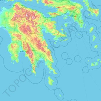
Name: Attica topographic map, elevation, terrain.
Location: Attica, Greece (35.72143 22.76581 38.37816 24.14635)
Average elevation: 155 m
Minimum elevation: -5 m
Maximum elevation: 2,327 m
Make a donation
Gear up for your next adventure:
As an Amazon Associate, this site earns from qualifying purchases at no extra cost to you.
Other topographic maps
Click on a map to view its topography, its elevation and its terrain.
Agios Nektarios
Greece > Attica > Regional Unit of West Attica > Municipal Unit of Vilia
Average elevation: 695 m
Ευαγγελίστριας
Greece > Attica > Regional Unit of Islands > Salamina Municipal Unit > Σατερλί
Average elevation: 23 m
Make a donation
Gear up for your next adventure:
As an Amazon Associate, this site earns from qualifying purchases at no extra cost to you.
Palaio Faliro
Greece > Attica > Regional Unit of South Athens
Phaleron was an important place in antiquity, then as now one of the demes of Athens; however, a precise definition of its Classical topography is lacking, although the location of the deme is well established. Pausanias records that it was on the coast, equidistant from Athens and Cape Kolias (i.e., Ayios…
Average elevation: 27 m
Methana
Greece > Attica > Regional Unit of Islands > Municipal Unit of Methana
Since 1991, the peninsula has been investigated by the team of ETH Zürich geologically and cartographically. From this, a topographical map of the entire peninsula at a scale of 1:25,000 was made. An interactive 3D map was created and is on the World Wide Web. Also a rich photographic archive with about…
Average elevation: 123 m
Make a donation
Gear up for your next adventure:
As an Amazon Associate, this site earns from qualifying purchases at no extra cost to you.
Astypalaia
Greece > Attica > Regional Unit of East Attica > Anavissos Municipal Unit
Average elevation: 10 m
Make a donation
Gear up for your next adventure:
As an Amazon Associate, this site earns from qualifying purchases at no extra cost to you.
Keratsini
Greece > Attica > Regional Unit of Piraeus > Municipal Unit of Keratsini
Average elevation: 73 m
Vilia
Greece > Attica > Regional Unit of West Attica > Municipal Unit of Vilia
Average elevation: 604 m
Make a donation
Gear up for your next adventure:
As an Amazon Associate, this site earns from qualifying purchases at no extra cost to you.
Ανάβυσσος
Greece > Attica > Regional Unit of East Attica > Anavissos Municipal Unit
Average elevation: 91 m
Make a donation
Gear up for your next adventure:
As an Amazon Associate, this site earns from qualifying purchases at no extra cost to you.
Christoupoli
Greece > Attica > Regional Unit of East Attica > Spata-Loutsa Municipal Unit
Average elevation: 122 m
Olympus
Greece > Attica > Regional Unit of North Athens > Municipal Unit of Psychiko
Average elevation: 204 m
Make a donation
Gear up for your next adventure:
As an Amazon Associate, this site earns from qualifying purchases at no extra cost to you.
Make a donation
Gear up for your next adventure:
As an Amazon Associate, this site earns from qualifying purchases at no extra cost to you.
Psatha
Greece > Attica > Regional Unit of West Attica > Municipal Unit of Vilia > Psatha
Average elevation: 79 m
Artemida
Greece > Attica > Regional Unit of East Attica > Artemida Municipal Unit
Average elevation: 38 m
Make a donation
Gear up for your next adventure:
As an Amazon Associate, this site earns from qualifying purchases at no extra cost to you.