
Tyrnavos Municipality topographic map
Interactive map
Click on the map to display elevation.
About this map
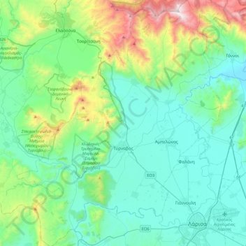
Name: Tyrnavos Municipality topographic map, elevation, terrain.
Average elevation: 297 m
Minimum elevation: 14 m
Maximum elevation: 1,408 m
Other topographic maps
Click on a map to view its topography, its elevation and its terrain.
Papapouli
Greece > Thessaly and Central Greece > Larisa Regional Unit > Municipal Unit of Kato Olympos
Average elevation: 10 m
Παραλία Κουλούρας
Greece > Thessaly and Central Greece > Larisa Regional Unit > Municipal Unit of Kato Olympos > Νέα Μεσάγγαλα
Average elevation: 0 m
Νέα Μεσάγγαλα
Greece > Thessaly and Central Greece > Larisa Regional Unit > Municipal Unit of Kato Olympos
Average elevation: 0 m
Agnanderi
Greece > Thessaly and Central Greece > Larisa Regional Unit > Municipal Unit of Kileler
Average elevation: 369 m
(Olympus)
Greece > Thessaly and Central Greece > Larisa Regional Unit > Municipal Unit of Gonnoi
Average elevation: 1,332 m
(Olympus)
Greece > Thessaly and Central Greece > Larisa Regional Unit > Municipal Unit of Gonnoi
Average elevation: 1,143 m
Falani
Greece > Thessaly and Central Greece > Larisa Regional Unit > Municipal Unit of Yiannouli
Average elevation: 68 m
Όλυμπος
Greece > Thessaly and Central Greece > Larisa Regional Unit > Elassona Municipality
Average elevation: 2,456 m
Σαραντάπορο
Greece > Thessaly and Central Greece > Larisa Regional Unit > Elassona Municipality > Σαραντάπορο
Average elevation: 797 m