
Make a donation
Gear up for your next adventure:
As an Amazon Associate, this site earns from qualifying purchases at no extra cost to you.
Arlesey topographic map
Click on the map to display elevation.
Make a donation
Gear up for your next adventure:
As an Amazon Associate, this site earns from qualifying purchases at no extra cost to you.
About this map
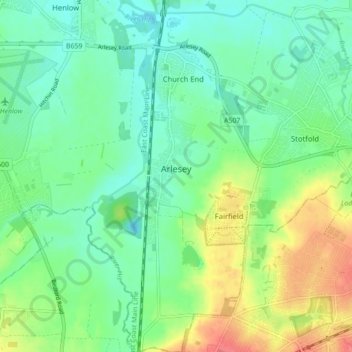
Name: Arlesey topographic map, elevation, terrain.
Location: Arlesey, Central Bedfordshire, England, United Kingdom (51.97959 -0.28404 52.03340 -0.23946)
Average elevation: 53 m
Minimum elevation: 33 m
Maximum elevation: 91 m
Central Bedfordshire trails, hiking, mountain biking, running and outdoor activities
Make a donation
Gear up for your next adventure:
As an Amazon Associate, this site earns from qualifying purchases at no extra cost to you.
Other topographic maps
Click on a map to view its topography, its elevation and its terrain.
Lower Caldecote
United Kingdom > England > Central Bedfordshire > Upper Caldecote
Average elevation: 32 m
Make a donation
Gear up for your next adventure:
As an Amazon Associate, this site earns from qualifying purchases at no extra cost to you.
Dunstable Downs
United Kingdom > England > Central Bedfordshire > Church End
Because of its elevation, Dunstable Downs hosted a station in the shutter telegraph chain which connected the Admiralty in London to its naval ships in the port of Great Yarmouth during the years 1808 to 1814.
Average elevation: 178 m
Make a donation
Gear up for your next adventure:
As an Amazon Associate, this site earns from qualifying purchases at no extra cost to you.
Edgecote
United Kingdom > England > Central Bedfordshire > Caddington > Aley Green
Average elevation: 168 m
Houghton Hall Park
United Kingdom > England > Central Bedfordshire > Houghton Regis
Average elevation: 134 m
Make a donation
Gear up for your next adventure:
As an Amazon Associate, this site earns from qualifying purchases at no extra cost to you.
Make a donation
Gear up for your next adventure:
As an Amazon Associate, this site earns from qualifying purchases at no extra cost to you.
Make a donation
Gear up for your next adventure:
As an Amazon Associate, this site earns from qualifying purchases at no extra cost to you.
Make a donation
Gear up for your next adventure:
As an Amazon Associate, this site earns from qualifying purchases at no extra cost to you.
Dog Kennel Down
United Kingdom > England > Central Bedfordshire > Houghton Regis
Average elevation: 138 m
Make a donation
Gear up for your next adventure:
As an Amazon Associate, this site earns from qualifying purchases at no extra cost to you.
Make a donation
Gear up for your next adventure:
As an Amazon Associate, this site earns from qualifying purchases at no extra cost to you.
Totternhoe Knolls
United Kingdom > England > Central Bedfordshire > Church End > Lower End
Average elevation: 105 m
Crawley Park
United Kingdom > England > Central Bedfordshire > Aspley Guise > Husborne Crawley
Average elevation: 98 m
Make a donation
Gear up for your next adventure:
As an Amazon Associate, this site earns from qualifying purchases at no extra cost to you.