
Amazon rainforest topographic map
Click on the map to display elevation.
About this map
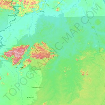
Name: Amazon rainforest topographic map, elevation, terrain.
Location: Amazon rainforest, Upper Takutu-Upper Essequibo, Guyana (2.97747 -59.90376 3.57078 -59.30604)
Average elevation: 255 m
Minimum elevation: 71 m
Maximum elevation: 1,045 m
Other topographic maps
Click on a map to view its topography, its elevation and its terrain.
Lethem Over the Creek
Guyana > Upper Takutu-Upper Essequibo > Ireng - Sawariwau
Average elevation: 90 m
Annai
Guyana > Upper Takutu-Upper Essequibo > Yakarinta - Wowetta - Surama
Annai stands at an altitude of 95 metres (314 feet), at the edge of the Rupununi savannah, where the cattle trail to the Atlantic coast begins. It is nestled in the foothills of the Pakaraima Mountains, and is close to the Rupununi River. Annai, considered to be the gateway to the Rupununi, is approximately 15…
Average elevation: 101 m
Upper Takutu-Upper Essequibo Region
Guyana > Upper Takutu-Upper Essequibo > Upper Takutu-Upper Essequibo Region
Average elevation: 221 m