
Municipio de San Luis topographic map
Interactive map
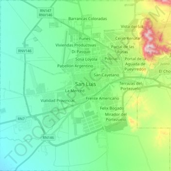
Click on the map to display elevation.
About this map
Name: Municipio de San Luis topographic map, elevation, terrain.
Average elevation: 734 m
Minimum elevation: 593 m
Maximum elevation: 1,191 m
San Luis (de la Punta) ist eine Stadt in der Region Cuyo in Argentinien und Hauptstadt der Provinz San Luis und deren Departamento Juan Martín de Pueyrredón. Die Stadt liegt am Fuße der Sierras Grandes auf einer Höhe von 762 m am Río Chorrillos und hat 153.322 Einwohner (2001, INDEC). San Luis liegt an der Ruta Nacional 7, die Mendoza (255 km) mit Buenos Aires (791 km) verbindet. Die nächstgelegenen Provinzhauptstädte sind San Juan (323 km) und Córdoba (412 km). Der Flughafen San Luis befindet sich sieben Kilometer vom Zentrum entfernt und verbindet die Stadt mit Buenos Aires.
Other topographic maps
Click on a map to view its topography, its elevation and its terrain.
Villa Reynolds
Argentinien > San Luis > Villa Mercedes > Villa Reynolds
Villa Reynolds, Villa Mercedes, General Pedernera, San Luis, D5730, Argentinien
Average elevation: 488 m
Juan Martín de Pueyrredón
Juan Martín de Pueyrredón, San Luis, Argentinien
Average elevation: 541 m